Marianne's Heaven On Earth Aurora Chaser Tours Chasethelighttours.co.uk invites you to join them in their quest to find and photograph the Aurora Borealis. Experience the winter wonderland in the Tromsø Area. | | |
GEOMAGNETIC STORM: Earlier today, March 11th, the outskirts of a CME previously expected to miss Earth instead hit. The impact sparked a G2-class geomagnetic storm (now subsiding) and bright auroras around the Arctic Circle. Tour guide Marketa S. Murray photographed the display just before sunrise near Fairbanks, Alaska:
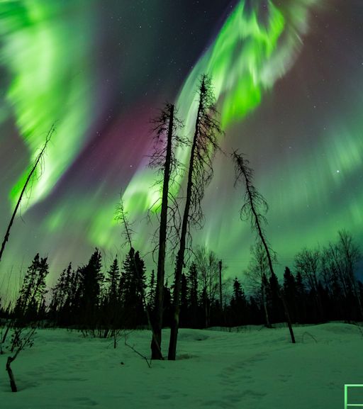
"We didn't expect to see much last night," says Murray. "Instead, it was an amazing night--all the colors you can imagine! Our guests were very happy."
This is a good time of year for auroras. For reasons that are only partially understood, geomagnetic storms favor the weeks around equinoxes; even a gentle gust of solar wind or, in this case, the sideswipe of an off-course CME can spark a good display. More lights are possible tonight as Earth moves deeper into the CME's flank. Monitor the aurora gallery for sightings. Aurora alerts: text or voice
Realtime Aurora Photo Gallery
AVIATION RADIATION EXPERIMENT--UPDATE: En route to observe the March 9th total eclipse in Indonesia, the students of Earth to Sky Calculus conducted an unusual experiment in aviation radiation. Their plane flew a great circle around the Pacific Ocean, skirting the Arctic Circle and crossing the equator in a relatively short period of time. Onboard the plane, they carried a cosmic ray balloon payload equipped with multiple radiation sensors. This allowed them to "take a snapshot" of dose rates over a wide range of latitudes. Here are some preliminary results:
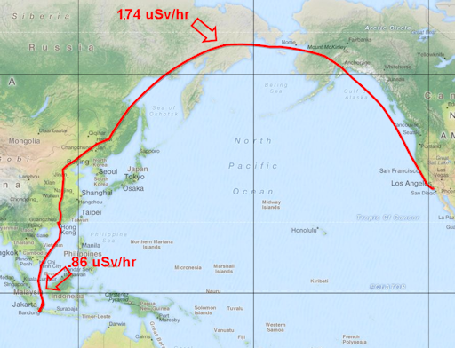
In the map, the red curve traces their flight path. Arrows point out dose rates at the highest and lowest latitudes. Throughout the trip, the plane was flying not far above 30,000 feet altitude. Students measured a 2:1 ratio of dose rates, Arctic vs. equator.
Researchers have long known that Earth's magnetic field near the equator provides a greater degree of protection against cosmic rays than Earth's magnetic field near the poles. This experiment answers the question, "How much greater?" (About 2 times.) It also builds upon Earth to Sky's ongoing study of aviation radiation which, before now, has been limited to latitudes inside the continental USA.
Radiation inside airplanes comes from deep space. Galactic cosmic rays are accelerated toward our planet by supernova explosions and other violent events in the cosmos. They penetrate the walls of aircraft with ease and have prompted the International Commission on Radiological Protection (ICRP) to classify pilots as occupational radiation workers.
The students are about to return to the United States, following approximately the same route in reverse. Will their preliminary results be confirmed? Stay tuned!
TOTAL ECLIPSE OF THE SUN: The March 9th solar eclipse is over--"and it was incredible," says Dana Crom of Earth to Sky Calculus, who witnessed the event from a beach on Belitung Island, Indonesia. "At first we thought we would not be able to see the eclipse, but morning clouds parted just in time for totality."
Indeed, all over Indonesia, observers spied the eclipse between and, more often, straight through clouds. Janne Pyykkö sends this picture from the nearby island of Terante:
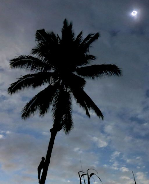
"With the help of local friends, I was able to find a coconut palm standing alone and two brave men willing to climb it for the photo," says Pyykkö. "During totality, high clouds muted the best sky colors. Even so, it was a fantastic experience."
On Belitung Island, Earth to Sky Calculus student Ginger Perez recorded a must-see video of totality. (Turn up the volume to hear the reaction of the crowd and the sound of ocean waves.) "It was hot when the sun rose this morning," says Ginger, "but the temperature dropped when the shadow of the Moon swept over us. It felt so nice! The slight ocean breeze made the eclipse sweeter still."
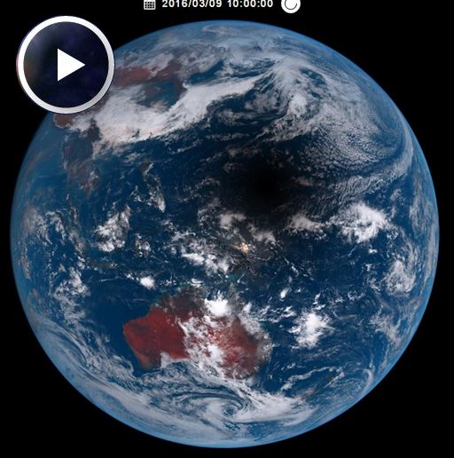
Japan's Sunflower-8 meteorological satellite saw the Moon's shadow from Earth orbit. Here it is racing across the Pacific on March 9th:
When the shadow engulfed Ternate, Indonesia, "the temperature dropped from 91.3F to 82.5F and the humidity increased from 73% to 85%," reports photographer Donald S. Gardner. "Roosters were crowing after totality."
Meanwhile, 30,000 feet above the Pacific, Alaska Airlines flight 870 from Anchorage to Honolulu diverted to fly through the path of totality. "I took photos every 2 seconds beginning 2 minutes before totality and ending 2 minutes after totality," reports passenger Evan Zucker who, fortunately, had a window seat:
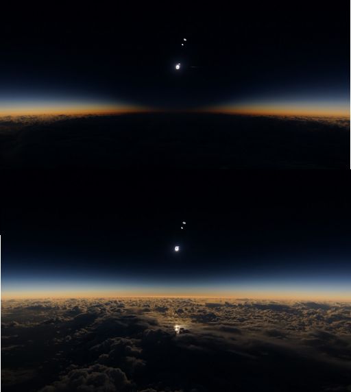
The top frame shows the view from the plane as it crossed the middle of the Moons shadow. The bottom frame shows light returning to the cloudtops as the plane began to exit. More of Zucker's airborne photos may be found here.
Browse the photo gallery for more tales from the eclipse zone:
Realtime Spaceweather Photo Gallery
Realtime Spaceweather Photo Gallery
Realtime Comet Photo Gallery
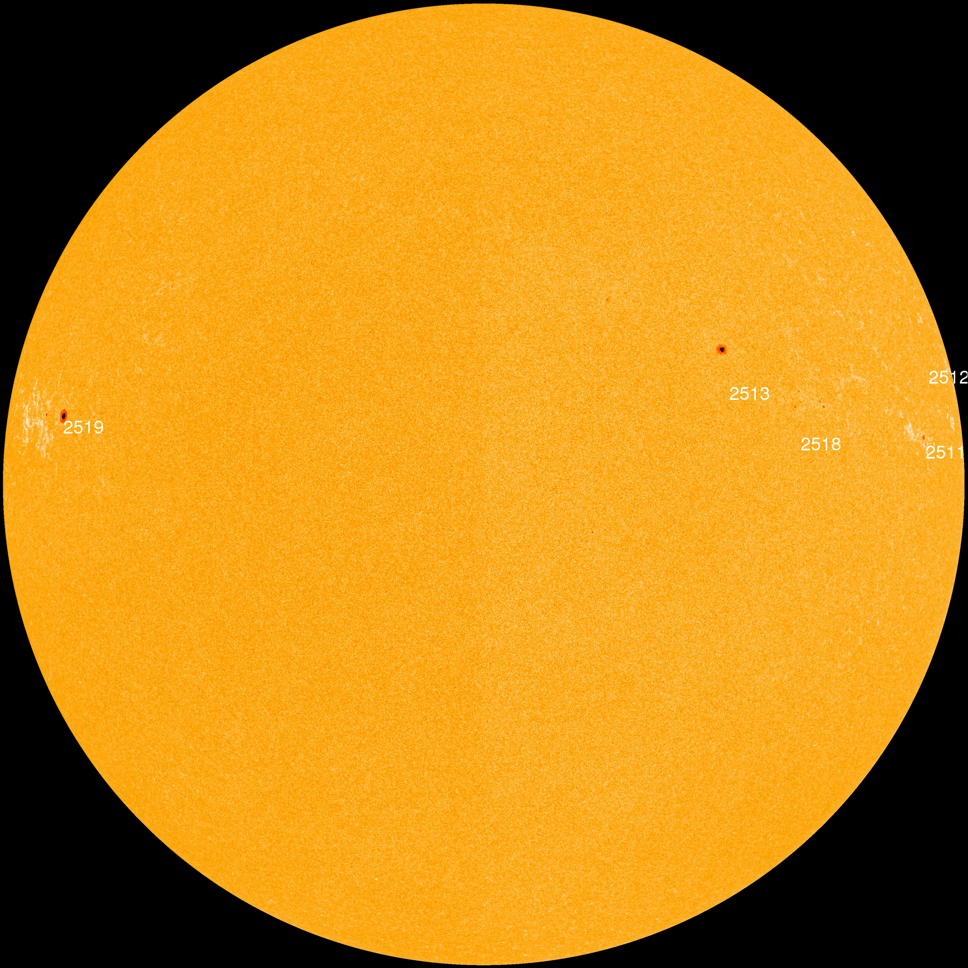
Every night, a network of
NASA all-sky cameras scans the skies above the United States for meteoritic fireballs. Automated software maintained by NASA's Meteoroid Environment Office calculates their orbits, velocity, penetration depth in Earth's atmosphere and many other characteristics. Daily results are presented here on Spaceweather.com.
On Mar. 11, 2016, the network reported 10 fireballs.
(10 sporadics)
In this diagram of the inner solar system, all of the fireball orbits intersect at a single point--Earth. The orbits are color-coded by velocity, from slow (red) to fast (blue). [Larger image] [movies]
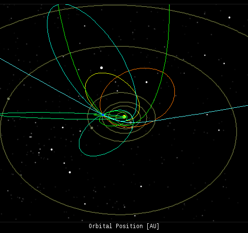
Potentially Hazardous Asteroids (
PHAs) are space rocks larger than approximately 100m that can come closer to Earth than 0.05 AU. None of the known PHAs is on a collision course with our planet, although astronomers are finding
new ones all the time.
On March 11, 2016 there were 1685 potentially hazardous asteroids.
Notes: LD means "Lunar Distance." 1 LD = 384,401 km, the distance between Earth and the Moon. 1 LD also equals 0.00256 AU. MAG is the visual magnitude of the asteroid on the date of closest approach. | | Cosmic Rays in the Atmosphere |
| Situation Report -- Oct. 30, 2015 | Stratospheric Radiation (+37o N) |
| Cosmic ray levels are elevated (+6.1% above the Space Age median). The trend is flat. Cosmic ray levels have increased +0% in the past month. |
| Sept. 06: 4.14 uSv/hr (414 uRad/hr) |
| Sept. 12: 4.09 uSv/hr (409 uRad/hr) |
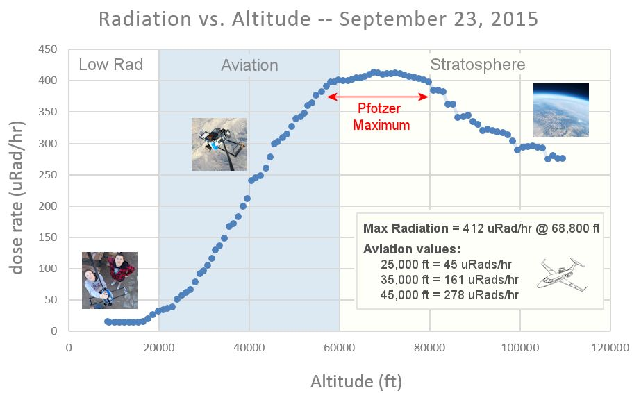
| Sept. 23: 4.12 uSv/hr (412 uRad/hr) |
| Sept. 25: 4.16 uSv/hr (416 uRad/hr) |
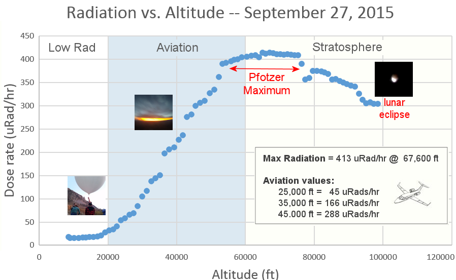
| Sept. 27: 4.13 uSv/hr (413 uRad/hr) |
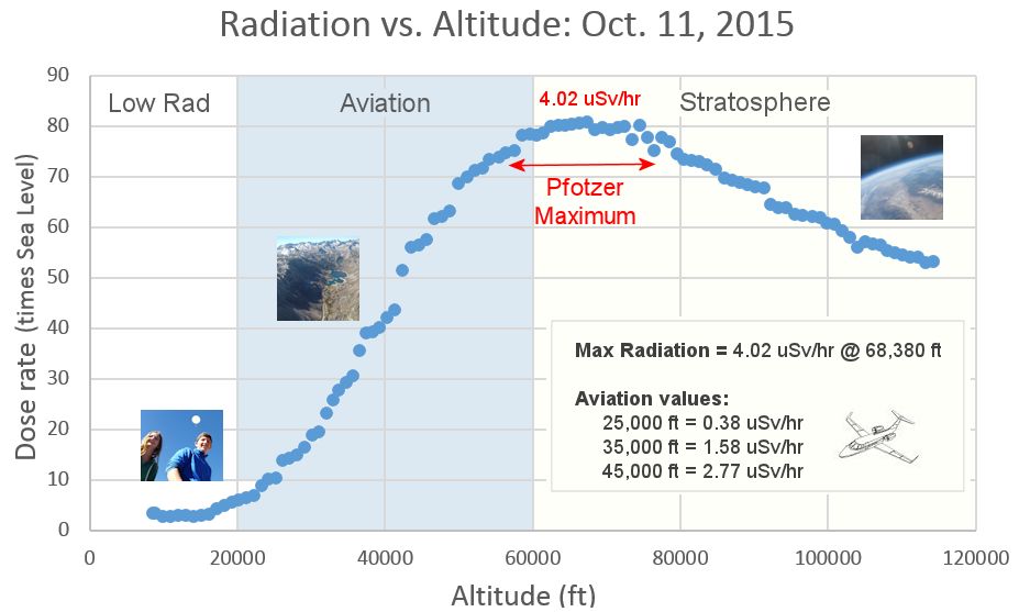
| Oct. 11: 4.02 uSv/hr (402 uRad/hr) |
| Oct. 22: 4.11 uSv/hr (411 uRad/hr) |
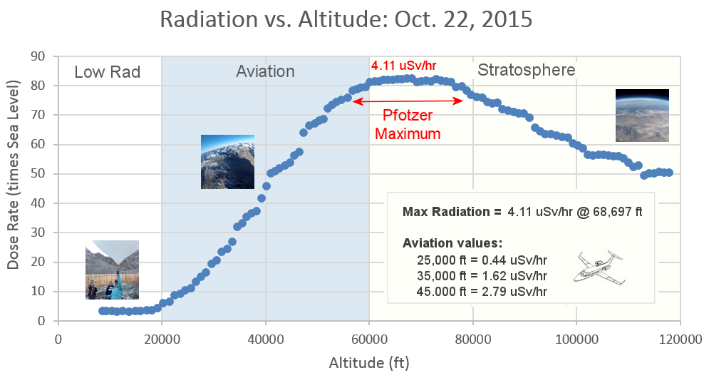
These measurements are based on regular space weather balloon flights: learn more. Approximately once a week, Spaceweather.com and the students of Earth to Sky Calculus fly "space weather balloons" to the stratosphere over California. These balloons are equipped with radiation sensors that detect cosmic rays, a surprisingly "down to Earth" form of space weather. Cosmic rays can seed clouds, trigger lightning, and penetrate commercial airplanes. Our measurements show that someone flying back and forth across the continental USA, just once, can absorb as much ionizing radiation as 2 to 5 dental X-rays. For example, here is the data from a flight on Oct. 22, 2015:
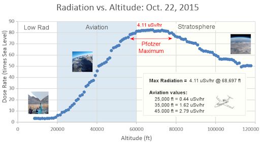
Radiation levels peak at the entrance to the stratosphere in a broad region called the "Pfotzer Maximum." This peak is named after physicist George Pfotzer who discovered it using balloons and Geiger tubes in the 1930s. Radiation levels there are more than 80x sea level.
Note that the bottom of the Pfotzer Maximim is near 55,000 ft. This means that some high-flying aircraft are not far from the zone of maximum radiation. Indeed, according to the Oct 22th measurements, a plane flying at 45,000 feet is exposed to 2.79 uSv/hr. At that rate, a passenger would absorb about one dental X-ray's worth of radiation in about 5 hours.
The radiation sensors onboard our helium balloons detect X-rays and gamma-rays in the energy range 10 keV to 20 MeV. These energies span the range of medical X-ray machines and airport security scanners.
| | The official U.S. government space weather bureau |
| | The first place to look for information about sundogs, pillars, rainbows and related phenomena. |
| | Researchers call it a "Hubble for the sun." SDO is the most advanced solar observatory ever. |
| | 3D views of the sun from NASA's Solar and Terrestrial Relations Observatory |
| | Realtime and archival images of the Sun from SOHO. |
| | from the NOAA Space Environment Center |
| | the underlying science of space weather |


