Directly under the Arctic Circle! Marianne's Arctic Xpress in Tromsø offers fjord, whale and wildlife tours by day, aurora tours by night. Book Now and get a 10% discount on combo day and night adventures. | | | AURORAS AND A FIREBALL: On Sept. 11th, Alex Conu went outdoors to photograph auroras over the Lofoten Islands of Norway. He got more than he bargained for. "BAM!" he says. "This -8 magnitude fireball streaked across the sky." 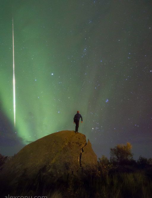
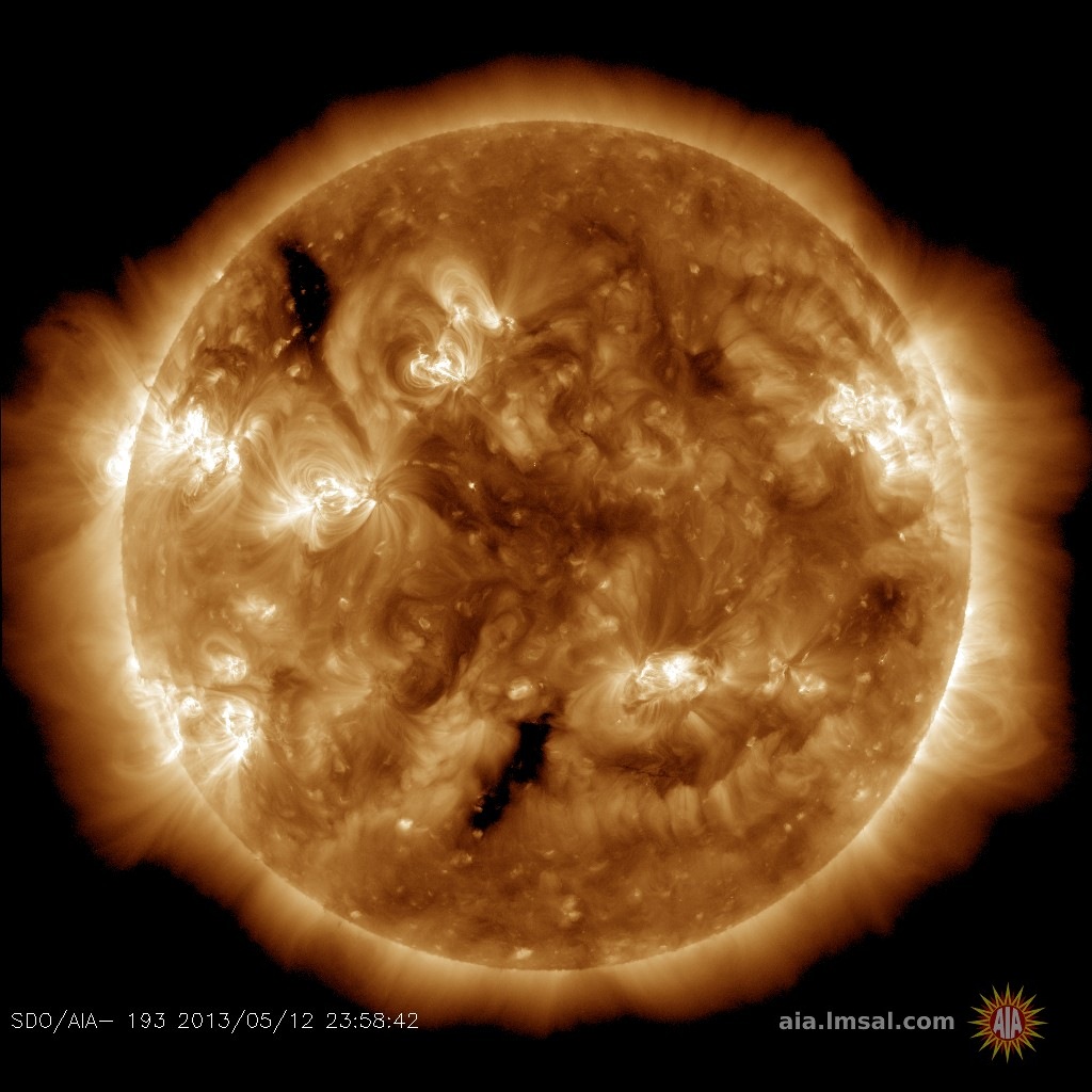
For comparison, the fireball was about as bright as the crescent Moon. "There was a bit of fragmenting towards the end," says Conu. "Very beautiful." The fireball won't be back tonight, Sept. 12th, but the auroras might. Earth is passing through a stream of solar wind filled with negative polarity (-Bz) magnetic fields. Such a solar wind stream can penetrate our planet's magnetic defenses, sparking geomagnetic storms and auroras. Aurora alerts: text or voice Realtime Aurora Photo Gallery MAGNIFICENT PROMINENCE: 93 million miles is a long way, but you wouldn't want to be any closer to the sun. Today's photo from Maximilian Teodorescu of Magurele, Romania, shows why: 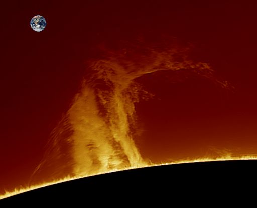
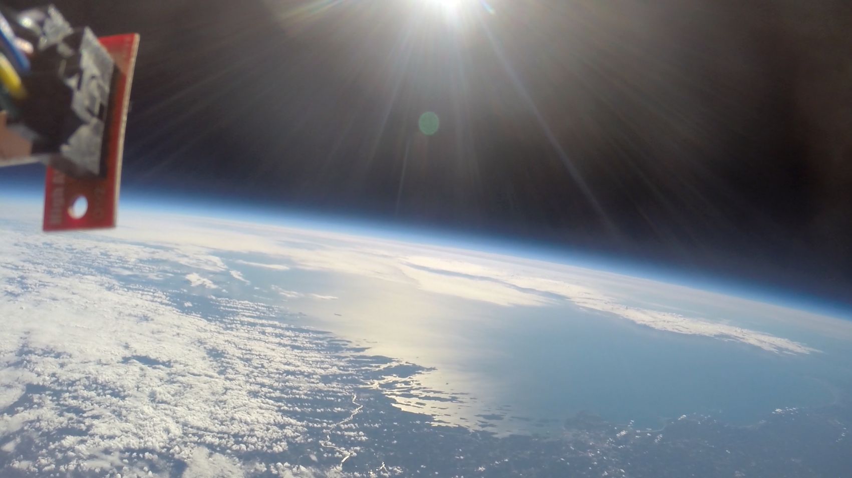
"There is a magnificent prominence on the western limb of the sun," says Teodorescu, who inserted a picture of our planet for scale. "Today it showed its true height--almost 10 times taller than Earth itself." Prominences are masses of hot plasma held above the surface of the sun by filaments of magnetism. Such structures are usually unstable and often collapse. This one has been intact for nearly two weeks, beating the odds. How long can it last? Amateur astronomers with backyard solar telescopes are encouraged to monitor developments. Realtime Aurora Photo Gallery A SPACE WEATHER BALLOON AT THE EDGE OF SPACE: On Friday, Sept. 2nd, Spaceweather.com and the students of Earth to Sky Calculus launched a research balloon from the slopes of Mt. Washington in New Hampshire. En route to measure radiation at the edge of space, the balloon's payload snapped this spherical image of the Atlantic Coast of Maine: The Atlantic Coast of Maine photographed from the stratosphere (108,000 feet) - Spherical Image - RICOH THETA The balloon popped at an altitude of 118,000 feet, about 10 minutes after it took this picture. Parachuting back to Earth, the payload landed in a forest of tall trees not far from Tripp Pond, Maine, where a combined team of students from Southern Maine Community College and Earth to Sky Calculus recovered it for analysis. This wasn't the only space weather balloon launched on Sept. 2nd. Earth to Sky students in California launched a second balloon at the same time. The transcontinental flight was part of an ongoing experiment to explore geographical variations in atmospheric radiation. Results? Here they are: 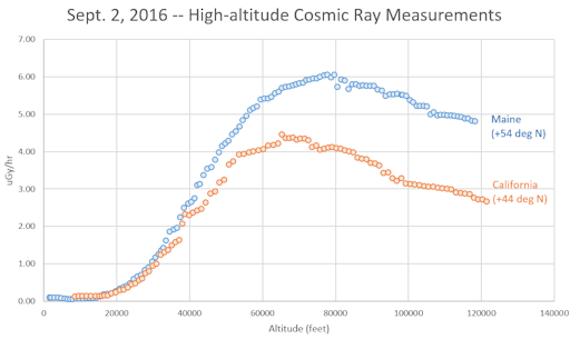
These profiles show the dose rate of secondary cosmic rays as a function of altitude over central California and southern Maine. Clearly, the atmosphere of Maine is more "radioactive." The reason can be found in the labels. The magnetic latitude in Maine (+54o) is higher than the magnetic latitude in California (+44o). In other words, Maine is closer to Earth's magnetic north pole where cosmic rays are more abundant. These results are of interest to air travelers, atmospheric scientists, and operators of high-altitude drones, among others. In a few days we'll release an even bigger data set showing results from Chile, California, Oregon and Washington. Stay tuned. More spherical images: (1) The launch site on the slopes of Mt. Washington, NH. (2) Emerging from the cloud layer over Mt. Washington, New Hampshire, the camera saw a ring of light in the clouds called a "glory." Realtime Space Weather Photo Gallery
Realtime Sprite Photo Gallery
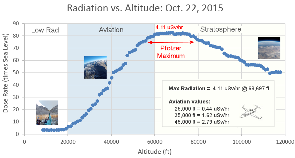
| | Cosmic Rays in the Atmosphere |
Updated: Sept.3, 2016 // Next Flight: Sept. 10, 2016
Sept. 3, 2016: On Sept. 2nd, Spaceweather.com and the students of Earth to Sky Calculus conducted a successful transcontinental launch of two space weather balloons--one from New Hampshire and another from California. The New Hampshire balloon recorded the highest levels of atmospheric radiation since our monitoring program began two years ago. Students are reducing the data now, and we will report the results in the coming week. While you wait, here is a shot of the Atlantic coast of Maine taken during the Sept. 2nd balloon flight from an altitude of 118,000 feet: 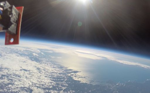
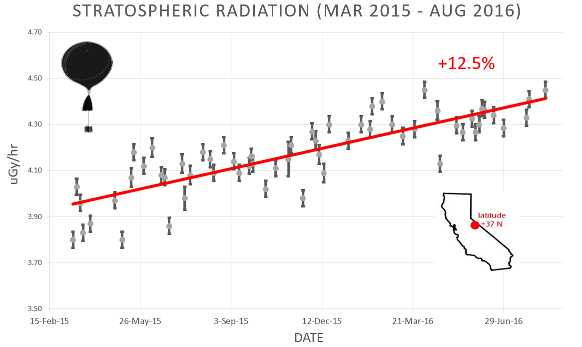
Approximately once a week, Spaceweather.com and the students of Earth to Sky Calculus fly space weather balloons to the stratosphere over California. These balloons are equipped with radiation sensors that detect cosmic rays, a surprisingly "down to Earth" form of space weather. Cosmic rays can seed clouds, trigger lightning, and penetrate commercial airplanes. Furthermore, there are studies ( #1, #2, #3, #4) linking cosmic rays with cardiac arrhythmias and sudden cardiac death in the general population. Our latest measurements show that cosmic rays are intensifying, with an increase of almost 13% since 2015: 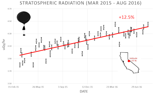
Why are cosmic rays intensifying? The main reason is the sun. Solar storm clouds such as coronal mass ejections (CMEs) sweep aside cosmic rays when they pass by Earth. During Solar Maximum, CMEs are abundant and cosmic rays are held at bay. Now, however, the solar cycle is swinging toward Solar Minimum, allowing cosmic rays to return. Another reason could be the weakening of Earth's magnetic field, which helps protect us from deep-space radiation. The radiation sensors onboard our helium balloons detect X-rays and gamma-rays in the energy range 10 keV to 20 MeV. These energies span the range of medical X-ray machines and airport security scanners. The data points in the graph above correspond to the peak of the Reneger-Pfotzer maximum, which lies about 67,000 feet above central California. When cosmic rays crash into Earth's atmosphere, they produce a spray of secondary particles that is most intense at the entrance to the stratosphere. Physicists Eric Reneger and Georg Pfotzer discovered the maximum using balloons in the 1930s and it is what we are measuring today. THIS RESEARCH IS CROWD-FUNDED: The cosmic ray research presented on Spaceweather.com is done by students, driven by curiosity, and funded entirely by readers. Our latest flight over California on Aug. 21st was sponsored by World Tech Toys of Valencia CA. In exchange for their generous donation of $750, we flew a toy Striker Drone to the edge of space: 
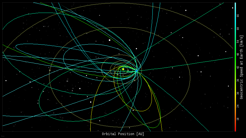
HD video and poster-quality images of the drone in space are now being used by World Tech Toys for marketing and outreach--an out-of-this-world bargain. Our next flights on Sept. 2nd and Sept. 10th need sponsors. Would you like to assist? Contact Dr. Tony Phillips to make arrangements. Every night, a network of NASA all-sky cameras scans the skies above the United States for meteoritic fireballs. Automated software maintained by NASA's Meteoroid Environment Office calculates their orbits, velocity, penetration depth in Earth's atmosphere and many other characteristics. Daily results are presented here on Spaceweather.com. On Sep. 12, 2016, the network reported 20 fireballs.
(18 sporadics, 2 September epsilon Perseids) 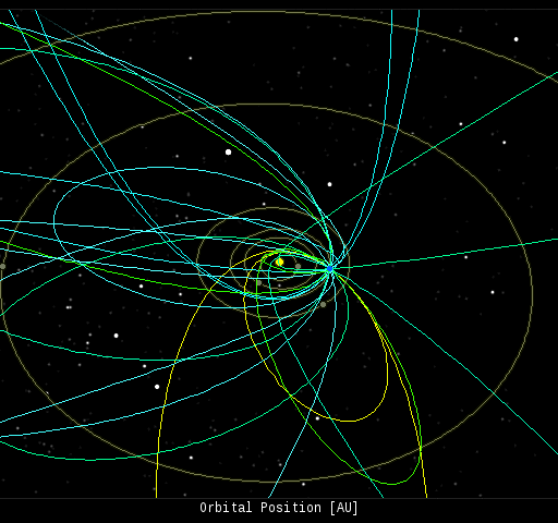 In this diagram of the inner solar system, all of the fireball orbits intersect at a single point--Earth. The orbits are color-coded by velocity, from slow (red) to fast (blue). [Larger image] [movies] Potentially Hazardous Asteroids ( PHAs) are space rocks larger than approximately 100m that can come closer to Earth than 0.05 AU. None of the known PHAs is on a collision course with our planet, although astronomers are finding new ones all the time. On September 12, 2016 there were potentially hazardous asteroids. Notes: LD means "Lunar Distance." 1 LD = 384,401 km, the distance between Earth and the Moon. 1 LD also equals 0.00256 AU. MAG is the visual magnitude of the asteroid on the date of closest approach. | | The official U.S. government space weather bureau | | | The first place to look for information about sundogs, pillars, rainbows and related phenomena. | | | Researchers call it a "Hubble for the sun." SDO is the most advanced solar observatory ever. | | | 3D views of the sun from NASA's Solar and Terrestrial Relations Observatory | | | Realtime and archival images of the Sun from SOHO. | | | from the NOAA Space Environment Center | | | a proud supporter of science education and Spaceweather.com | | | the underlying science of space weather |  | Find homes for sale in Ocala, Orlando and Tampa with the #1 real estate company in Central Florida Local Realty Service | | Claim your tax refund with this UK tax rebate company and get back your overpaid tax. | | Enjoy this fabulous range of leather sofas from a leader in the UK sofa manufacturer industry.. | | | This link helps Spaceweather.com stay online. Thank you to our supporters! | | | This link helps Spaceweather.com stay online. Thank you to our supporters! | | | These links help Spaceweather.com stay online. Thank you to our supporters! | | 


