Marianne's Heaven On Earth Aurora Chaser Tours Chasethelighttours.co.uk invites you to join them in their quest to find and photograph the Aurora Borealis. Experience the winter wonderland in the Tromsø Area. | | | CONTINUED QUIET: Solar activity is very low and likely to remain so for the next 24 hours. NOAA forecasters estimate a 5% chance of M-flares and no more than a 1% chance of X-flares on Jan. 13th. Solar flare alerts: text or voice. AURORAS VISIBLE FROM SPACE: For the third day in a row, a stream of high-speed solar wind is buffeting Earth's magnetic field. This is sparking a light show visible from Earth orbit. Dramatic images from the US Defense Meteorological Satellite Program (DMSP) show auroras over the polar regions north of Russia, Alaska, and Canada: 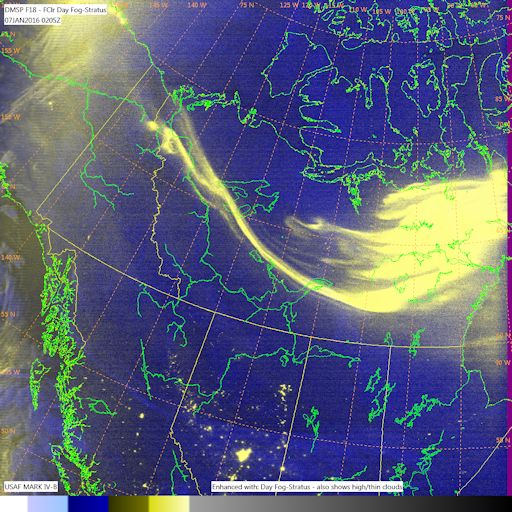
"These images of brilliant aurora borealis use both nighttime visual and infrared data from the Suomi NPP and DMSP F14, F18, & F19 polar orbiting satellites," reports says Paul McCrone of the Fleet Numerical Meteorology and Oceanography Center in Monterey, California. He processed the data on Jan. 11, 2016. DMSP satellites carry low light cameras for nightime monitoring of moonlit clouds, city lights and auroras. Some of the auroras recorded by the fleet on Jan. 11th were as bright as the city lights underneath. "This imagery was generated from the Operational Linescan System (OLS) on the DMSP spacecraft, revealing the sinuous path of these energetic particles entering Earth's upper atmosphere," adds McCrone. More auroras like these are possible on Jan. 13th. NOAA forecasters estimate a 50% chence of polar geomagnetic storms during the next 24 hours as the solar wind continues to blow. Aurora alerts: text or voice. Realtime Aurora Photo Gallery AURORAS VS. LIGHT PILLARS: Last night in Muonio, Finland, Antti Pietikäinen hiked out onto the frozen surface of the River Muonio to get away from glaring city lights. "I was trying to get a better view of the auroras," he says. Turns out, he got a great view of both: 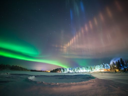
"I had a rare shot with auroras and light pillars in the same image," says Pietikäinen. Light pillars are a common sight around northern cities in winter. Urban lights bounce off ice crystals in the air, producing tall luminous columns sometimes mistaken for auroras.
"The night air was filled with ice crystals as the temperature dropped to -35 C," he says. "This created stunning light pillars on top of the Hotel Harriniva. The funny crater in the foreground is because the ice has frozen unevenly in the river, creating a small pond that overflows water regularly. Water with slush freezes on top heightening the crater walls."
"It's quite nice to live in the aurora zone," says Pietikäinen, "every evening is different." Realtime Spaceweather Photo Gallery LEAPING SUNDOGS: At this time of year, when northern skies fill with crystals of ice, it is not unusual to see rainbow-colored splashes of light to the left and right of the sun. These are sundogs, formed by the action of ice on sunlight. Yesterday, the daughter of photographer Robert Snache saw a sundog ... and leaped: 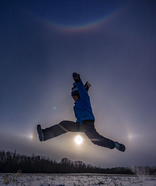
"We had snow squalls in the late afternoon--hence the ice crystals," says Snache, who took the picture from Rama First Nation, Ontario, Canada. "The same crystals formed a smiling rainbow (circumzenithal arc) overhead and a faint 22° halo around the sun. It was a beautiful display of ice halos." More ice halos are in the offing as northern winter deepens. Browse the gallery for sightings.
Realtime Meteor Photo Gallery
Realtime Comet Photo Gallery
Every night, a network of NASA all-sky cameras scans the skies above the United States for meteoritic fireballs. Automated software maintained by NASA's Meteoroid Environment Office calculates their orbits, velocity, penetration depth in Earth's atmosphere and many other characteristics. Daily results are presented here on Spaceweather.com. On Jan. 13, 2016, the network reported 14 fireballs.
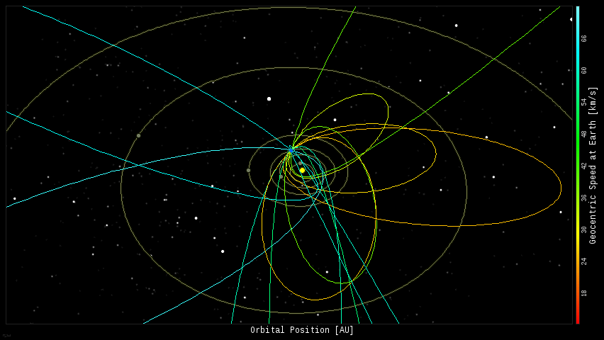
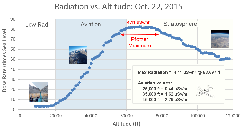
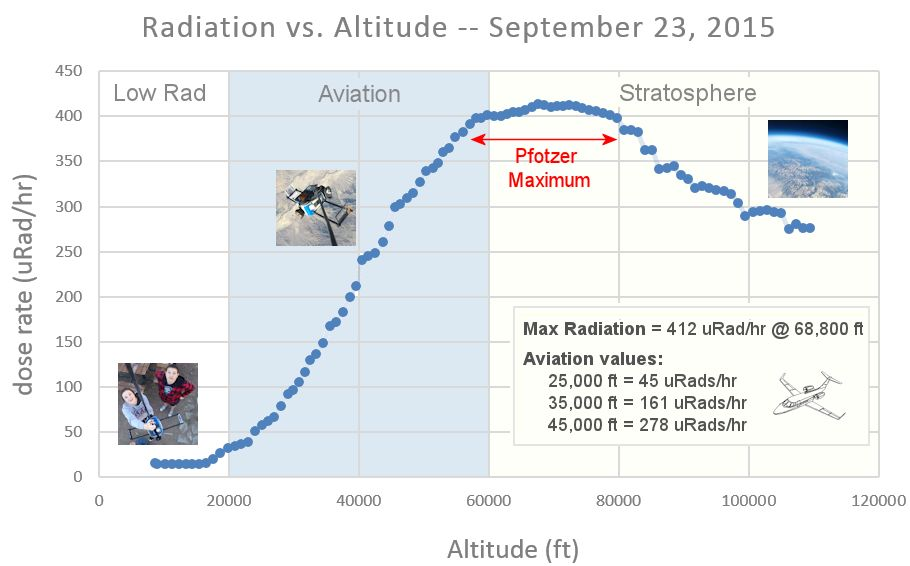
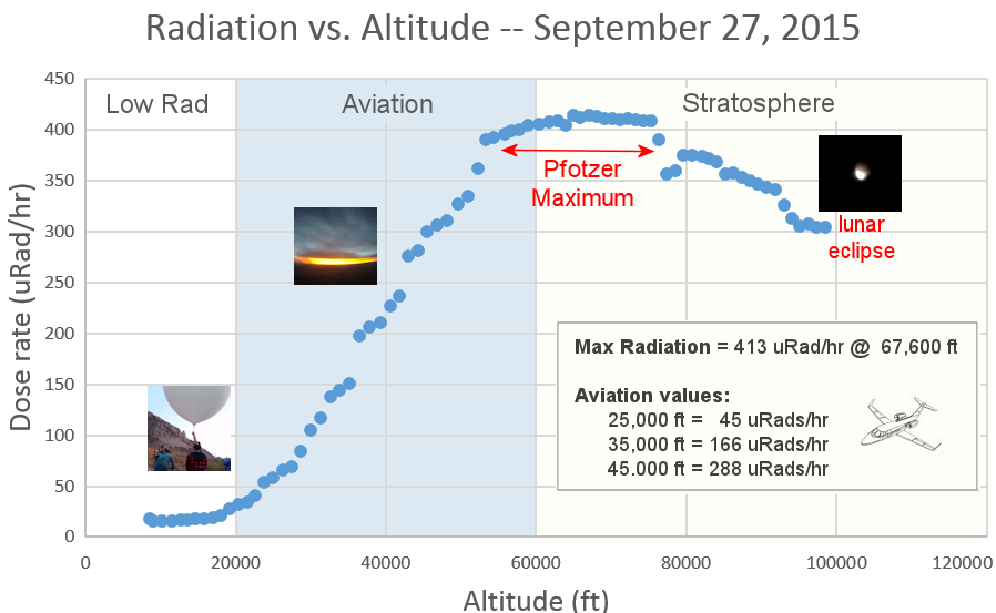
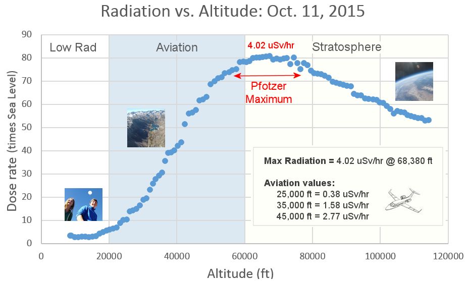
(14 sporadics) 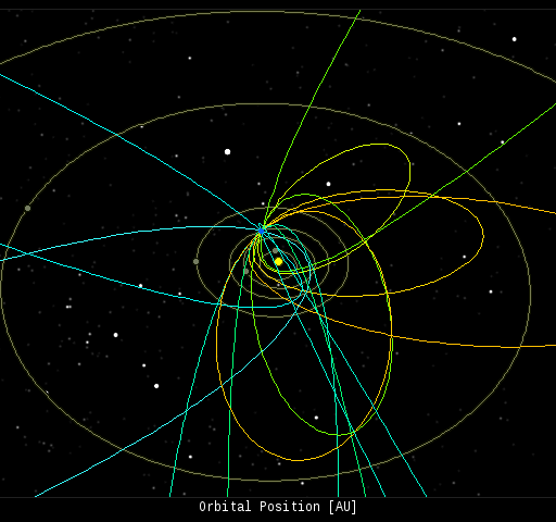 In this diagram of the inner solar system, all of the fireball orbits intersect at a single point--Earth. The orbits are color-coded by velocity, from slow (red) to fast (blue). [Larger image] [movies] Potentially Hazardous Asteroids ( PHAs) are space rocks larger than approximately 100m that can come closer to Earth than 0.05 AU. None of the known PHAs is on a collision course with our planet, although astronomers are finding new ones all the time. On January 13, 2016 there were potentially hazardous asteroids. Notes: LD means "Lunar Distance." 1 LD = 384,401 km, the distance between Earth and the Moon. 1 LD also equals 0.00256 AU. MAG is the visual magnitude of the asteroid on the date of closest approach. | | Cosmic Rays in the Atmosphere | | Situation Report -- Oct. 30, 2015 | Stratospheric Radiation (+37o N) | | Cosmic ray levels are elevated (+6.1% above the Space Age median). The trend is flat. Cosmic ray levels have increased +0% in the past month. | | Sept. 06: 4.14 uSv/hr (414 uRad/hr) | | Sept. 12: 4.09 uSv/hr (409 uRad/hr) | | Sept. 23: 4.12 uSv/hr (412 uRad/hr) | | Sept. 25: 4.16 uSv/hr (416 uRad/hr) | | Sept. 27: 4.13 uSv/hr (413 uRad/hr) | | Oct. 11: 4.02 uSv/hr (402 uRad/hr) | | Oct. 22: 4.11 uSv/hr (411 uRad/hr) | These measurements are based on regular space weather balloon flights: learn more. Approximately once a week, Spaceweather.com and the students of Earth to Sky Calculus fly "space weather balloons" to the stratosphere over California. These balloons are equipped with radiation sensors that detect cosmic rays, a surprisingly "down to Earth" form of space weather. Cosmic rays can seed clouds, trigger lightning, and penetrate commercial airplanes. Our measurements show that someone flying back and forth across the continental USA, just once, can absorb as much ionizing radiation as 2 to 5 dental X-rays. Here is the data from our latest flight, Oct. 22nd: 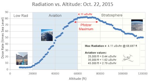
Radiation levels peak at the entrance to the stratosphere in a broad region called the "Pfotzer Maximum." This peak is named after physicist George Pfotzer who discovered it using balloons and Geiger tubes in the 1930s. Radiation levels there are more than 80x sea level. Note that the bottom of the Pfotzer Maximim is near 55,000 ft. This means that some high-flying aircraft are not far from the zone of maximum radiation. Indeed, according to the Oct 22th measurements, a plane flying at 45,000 feet is exposed to 2.79 uSv/hr. At that rate, a passenger would absorb about one dental X-ray's worth of radiation in about 5 hours. The radiation sensors onboard our helium balloons detect X-rays and gamma-rays in the energy range 10 keV to 20 MeV. These energies span the range of medical X-ray machines and airport security scanners. | | The official U.S. government space weather bureau | | | The first place to look for information about sundogs, pillars, rainbows and related phenomena. | | | Researchers call it a "Hubble for the sun." SDO is the most advanced solar observatory ever. | | | 3D views of the sun from NASA's Solar and Terrestrial Relations Observatory | | | Realtime and archival images of the Sun from SOHO. | | | from the NOAA Space Environment Center | | | the underlying science of space weather | | | Web-based high school science course with free enrollment | | 


