Marianne's Heaven On Earth Aurora Chaser Tours Chasethelighttours.co.uk invites you to join them in their quest to find and photograph the Aurora Borealis. Experience the winter wonderland in the Tromsø Area. | | | WEAK IMPACT, GREEN AURORAS: A slow-moving CME hit Earth's magnetic field on Jan. 18th at ~2100 UT. The gentle impact did not cause a full-fledged geomagnetic storm, but the aurora borealis appeared anyway. Truls Tiller photographed the lights from Ersfjorden, just outside Tromsø, Norway: 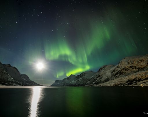
"The bright moon lit up the mountains around the fjord, framing the auroras beautifully," says Tiller. More auroras could be in the offing. NOAA forecasters estimate a 45% chance of geomagnetic storms on Jan. 19th as Earth passes through the wake of the CME. Aurora alerts: text or voice. Realtime Aurora Photo Gallery SOLAR ECLIPSE BALLOON NETWORK: Spaceweather.com and the students of Earth to Sky Calculus have developed a balloon payload that can photograph solar eclipses from the stratosphere. This sets the stage for a one-of-a-kind photography experiment: On August 21, 2017, the Moon will pass in front of the sun over the USA, producing a total eclipse visible from coast to coast. We will launch balloons to record the event from a dozen points along the path of totality: 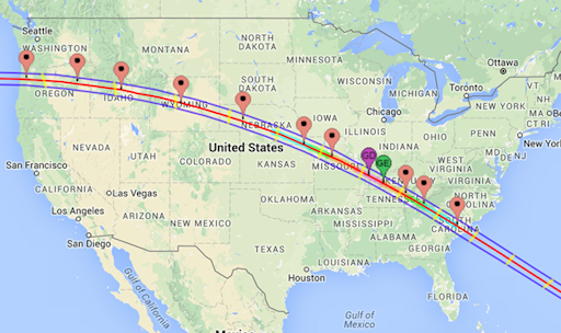 Floating more than 100,000 feet above the clouds, the balloons will have an unobstructed view of the eclipse. From each of a dozen payloads, one camera will point up to record the sun's ghostly corona while another camera points down to record the passage of the Moon's dark shadow across the landscape and cloudtops below. When the eclipse is finished, we will combine the footage to create a unique video portrait of an eclipse sweeping across the American continent. The finished product will be a one-of-a-kind synthesis of art, technology and science. The payload has already photographed a partial solar eclipse in Oct. 2014: images. To test the payload under conditions of totality, a team of students and parents from Earth to Sky Calculus will travel to Indonesia six weeks from now to observe the March 9, 2016, total eclipse: animated map. Stay tuned for news from their expedition! Readers, would you like to join the Solar Eclipse Balloon Network? Starting now we are recruiting teams of citizen scientists who we will train in the art of high-altitude ballooning to become members of the solar eclipse launch crews. Schools, scout troops, home school families and others are welcome to apply. This is a great way for novices to learn ballooning and to participate in authentic science. We will also be seeking sponsors for the 12 payloads. Contact Dr. Tony Phillips to register your interest. Realtime Spaceweather Photo Gallery SKI HALOS: For people in the northern hemisphere, now is the time to go skiing. Little known fact: Ski resorts are great places to see ice halos. Christian Schartner photographed this specimen on Jan. 18th in the Hochkönig mountain ski area of Austria: 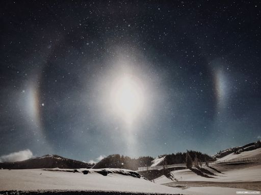
"After days of snowfall and cold temperatures, the sun finally came out again here at Hochkönig," says Schartner. "The temperature was -15 C, and the air was filled with glittering ice crystals. When sunlight hit those crystals, the ski-halos appeared. It was magical." Snow-making machines at ski resorts can intensify these displays. Diamond dust ice crystals grow slowly downwind of snow blowers and fill the air. These man-made crystals tend to be more optically perfect than crystals in clouds and so they produce bright, sharp and often very rare halos. Going skiing? Be alert for halos. More examples may be found in the realtime photo gallery.
Realtime Meteor Photo Gallery
Realtime Comet Photo Gallery Every night, a network of NASA all-sky cameras scans the skies above the United States for meteoritic fireballs. Automated software maintained by NASA's Meteoroid Environment Office calculates their orbits, velocity, penetration depth in Earth's atmosphere and many other characteristics. Daily results are presented here on Spaceweather.com. On Jan. 19, 2016, the network reported 15 fireballs.
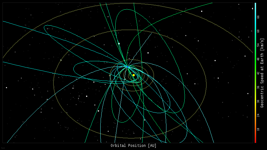
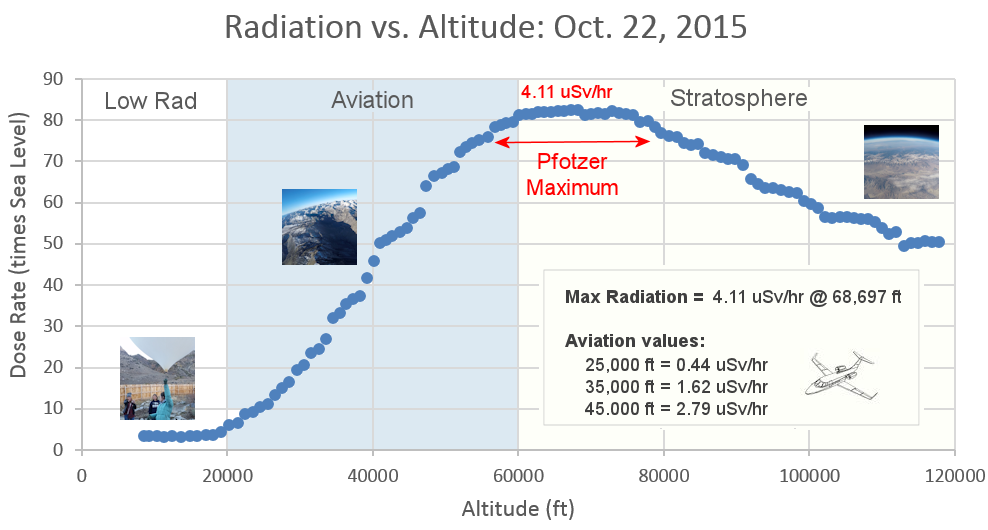
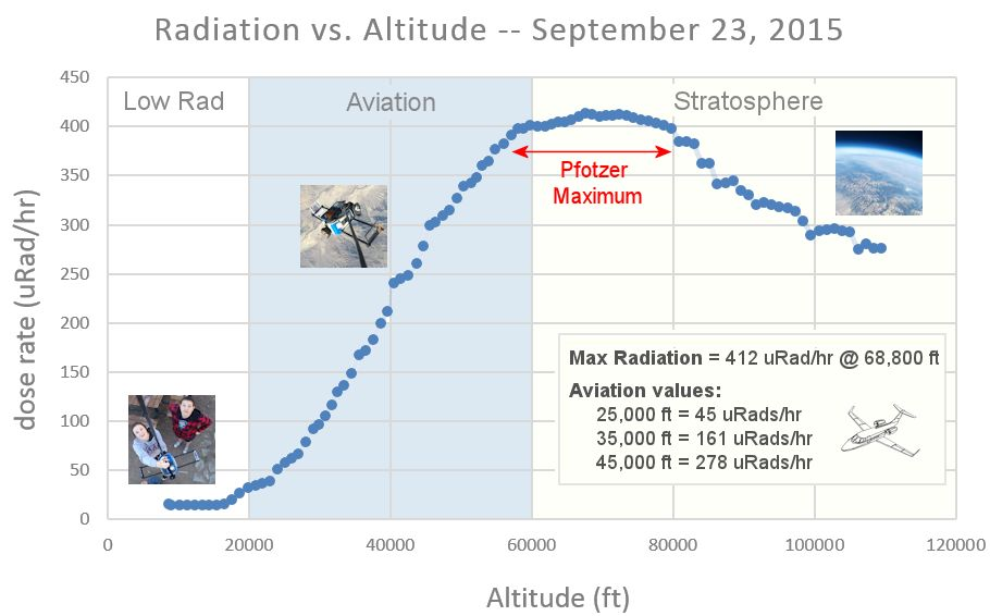
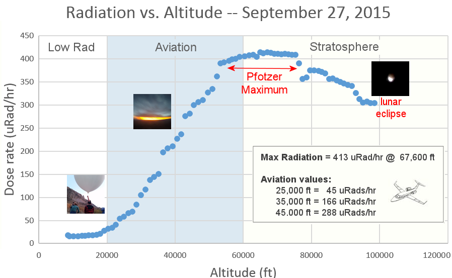
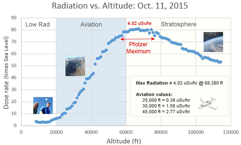
(15 sporadics) 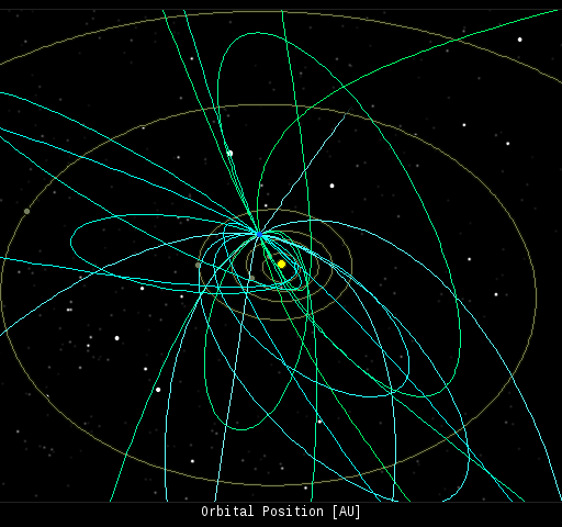 In this diagram of the inner solar system, all of the fireball orbits intersect at a single point--Earth. The orbits are color-coded by velocity, from slow (red) to fast (blue). [Larger image] [movies] Potentially Hazardous Asteroids ( PHAs) are space rocks larger than approximately 100m that can come closer to Earth than 0.05 AU. None of the known PHAs is on a collision course with our planet, although astronomers are finding new ones all the time. On January 19, 2016 there were 1655 potentially hazardous asteroids. Notes: LD means "Lunar Distance." 1 LD = 384,401 km, the distance between Earth and the Moon. 1 LD also equals 0.00256 AU. MAG is the visual magnitude of the asteroid on the date of closest approach. | | Cosmic Rays in the Atmosphere | | Situation Report -- Oct. 30, 2015 | Stratospheric Radiation (+37o N) | | Cosmic ray levels are elevated (+6.1% above the Space Age median). The trend is flat. Cosmic ray levels have increased +0% in the past month. | | Sept. 06: 4.14 uSv/hr (414 uRad/hr) | | Sept. 12: 4.09 uSv/hr (409 uRad/hr) | | Sept. 23: 4.12 uSv/hr (412 uRad/hr) | | Sept. 25: 4.16 uSv/hr (416 uRad/hr) | | Sept. 27: 4.13 uSv/hr (413 uRad/hr) | | Oct. 11: 4.02 uSv/hr (402 uRad/hr) | | Oct. 22: 4.11 uSv/hr (411 uRad/hr) | These measurements are based on regular space weather balloon flights: learn more. Approximately once a week, Spaceweather.com and the students of Earth to Sky Calculus fly "space weather balloons" to the stratosphere over California. These balloons are equipped with radiation sensors that detect cosmic rays, a surprisingly "down to Earth" form of space weather. Cosmic rays can seed clouds, trigger lightning, and penetrate commercial airplanes. Our measurements show that someone flying back and forth across the continental USA, just once, can absorb as much ionizing radiation as 2 to 5 dental X-rays. Here is the data from our latest flight, Oct. 22nd: 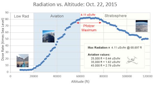
Radiation levels peak at the entrance to the stratosphere in a broad region called the "Pfotzer Maximum." This peak is named after physicist George Pfotzer who discovered it using balloons and Geiger tubes in the 1930s. Radiation levels there are more than 80x sea level. Note that the bottom of the Pfotzer Maximim is near 55,000 ft. This means that some high-flying aircraft are not far from the zone of maximum radiation. Indeed, according to the Oct 22th measurements, a plane flying at 45,000 feet is exposed to 2.79 uSv/hr. At that rate, a passenger would absorb about one dental X-ray's worth of radiation in about 5 hours. The radiation sensors onboard our helium balloons detect X-rays and gamma-rays in the energy range 10 keV to 20 MeV. These energies span the range of medical X-ray machines and airport security scanners. | | The official U.S. government space weather bureau | | | The first place to look for information about sundogs, pillars, rainbows and related phenomena. | | | Researchers call it a "Hubble for the sun." SDO is the most advanced solar observatory ever. | | | 3D views of the sun from NASA's Solar and Terrestrial Relations Observatory | | | Realtime and archival images of the Sun from SOHO. | | | from the NOAA Space Environment Center | | | the underlying science of space weather | | | Web-based high school science course with free enrollment | | 


