Learn to photograph Northern Lights like a pro. Sign up for Peter Rosen's Aurora Photo Courses in Abisko National Park. | | |
TOTAL SOLAR ECLIPSE: For the first time in months, the sun is rising over the Arctic--just in time for the Moon to blot it out. On March 20th, the first day of northern spring, the new Moon will pass in front of the sun, producing a total solar eclipse. The narrow path of totality curves through the Arctic Ocean, cutting across Svalbard and the Faroe Islands, where people from around the world are converging to stand inside the Moon's cool shadow. While totality plays out in the Arctic Ocean, a partial eclipse cann be seen from most of Europe, Iceland, Greenland, and parts of Asia. For a quick preview, see the animated eclipse map from ShadowAndSubstance.com.
GEOMAGNETIC STORM, CONTINUED: Earth's magnetic field is still reverberating from a CME strike on March 17th that sparked the strongest geomagnetic storm of the current solar cycle. At its peak on St. Patrick's Day--make that St. Patrick's Night--the G4-class storm pushed Northern Lights across the Canadian border into more than a dozen US states including New York, Washington, Iowa, Minnesota, Michigan, Oregon, Massachusetts and even Kansas. The auroras have since retreated north, but they are still glowing, as shown in this March 19th photo from Svalbard, site of tomorrow's total eclipse:
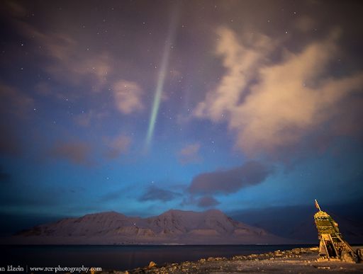
"Luckily the clouds parted here in Svalbard around 1 a.m.--just in time to see a nice Aurora strip in the sky!" says photographer Rayann Elzein. "Why just in time? Here at 78°N days are getting longer very fast this time of year, and dawn was already underway at 1 a.m. as you can see on the photo behind the mountains. Tonight the weather forecast is much better so lets hope for more auroras. And of course stay tuned for all the stories about tomorrows solar eclipse!"
Will sky watchers in Svalbard see a total eclipse and auroras at the same time?! NOAA forecasters estimate a 60% chance of polar geomagnetic storms on March 19th as Earth exits the CME's wake. Aurora alerts: text, voice
Realtime Aurora Photo Gallery
Geomagnetic storms do more than just produce auroras. Amateur radio operators noticed strong disruptions to long-distance communications. David Hassall (WA5DJJ) of Las Cruces, New Mexico, sends this report: "Shortly after the CME hit on March 17th, we experienced strong disruptions on the 30 meter (10 MHz) band. [Pictured below] is a screenshot of 200 mW transmissions on the path between Las Cruces, New Mexico and Northland, New Zealand as received by ZL2IK."
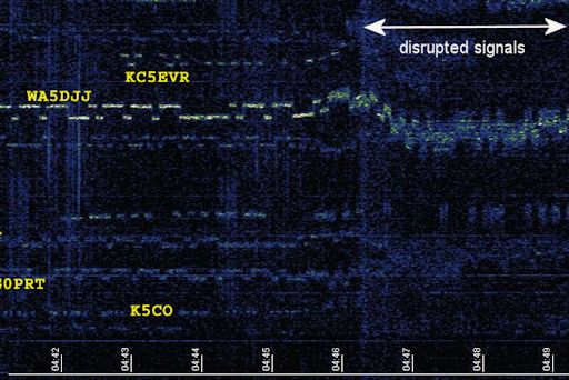
"The signal disruption happened on this radio path at 04:46 UTC (about 15 minutes after the CME arrived) and shifted the frequency of mine and other signals which were traversing that path. We are always studying the effects of solar events on our tiny signals and from this screenshot you see that they can be quite dynamic. Signals from England on this screenshot were affected differently than the ones from the USA."
Realtime Space Weather Photo Gallery
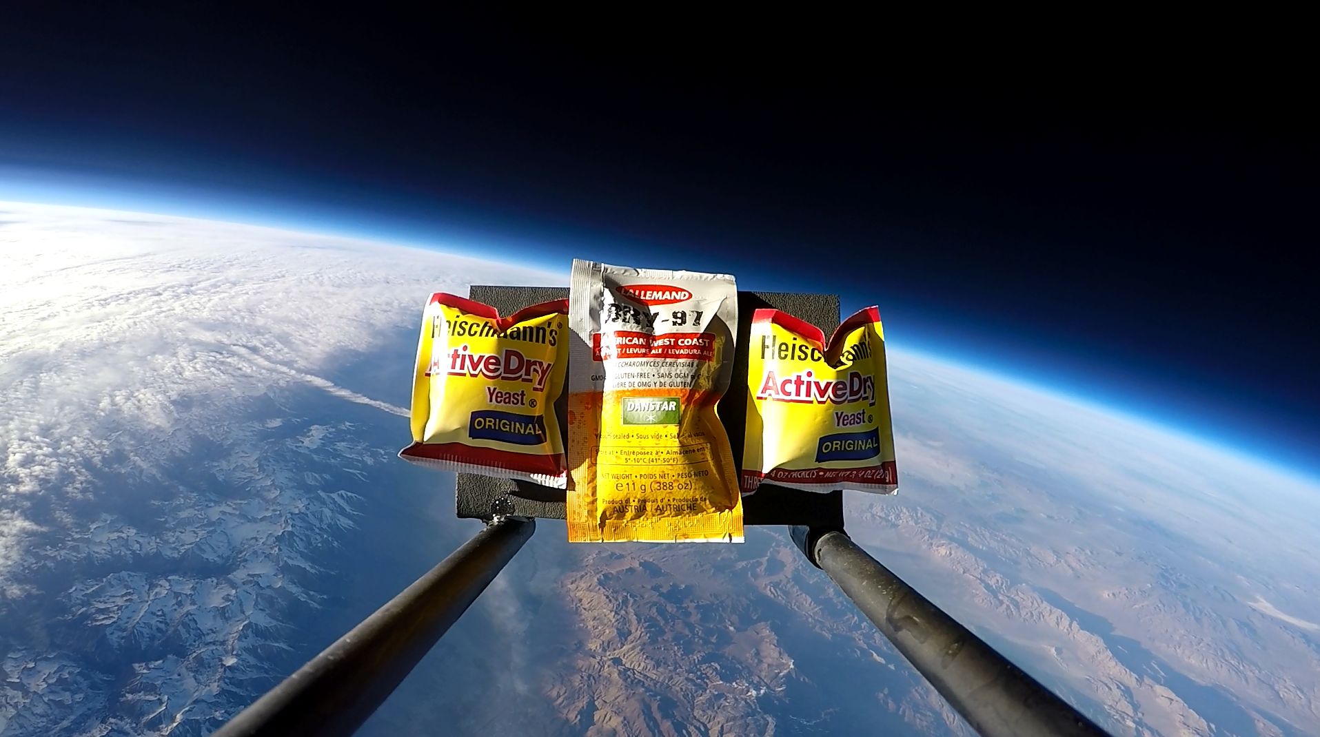
SPACE YEAST: On March 17th, Spaceweather.com and the students of Earth to Sky Calculus flew a Space Weather Buoy into the geomagnetic storm to measure the effect of the CME's impact on cosmic rays in the stratosphere. Along with radiation detectors and other sensors, the payload carried some hitchhikers--brewer's and baker's yeast:
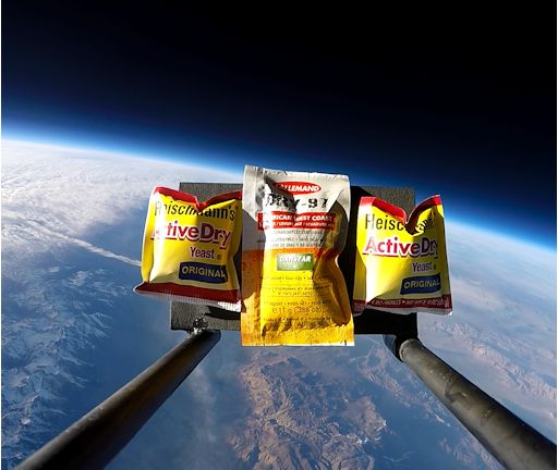
During their ascent to the stratosphere, the yeast experienced temperatures as low as -60 C, air pressures only 1% of sea level, and cosmic ray dose rates 40 times Earth-normal.
What can you do with Space Yeast? Bake space bread, brew space beer, or whip up any recipe that calls for yeast. Also, teachers and homeschoolers can conduct some cool classroom experiments.
If you would like a packet of space yeast, you can have one by making a donation of $49.95 to Earth to Sky Calculus. Every flown packet of baker's yeast comes with a control packet that remained behind on Earth during the flight, so you can conduct a properly-controlled scientific experiment. All proceeds support student space weather research. Contact Dr. Tony Phillips to place your order.
Realtime Comet Photo Gallery
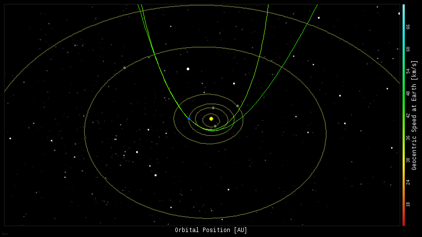
Every night, a network of NASA all-sky cameras scans the skies above the United States for meteoritic fireballs. Automated software maintained by NASA's Meteoroid Environment Office calculates their orbits, velocity, penetration depth in Earth's atmosphere and many other characteristics. Daily results are presented here on Spaceweather.com.
On Mar. 19, 2015, the network reported 2 fireballs.
(2 sporadics)
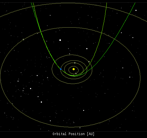
In this diagram of the inner solar system, all of the fireball orbits intersect at a single point--Earth. The orbits are color-coded by velocity, from slow (red) to fast (blue). [Larger image] [movies]
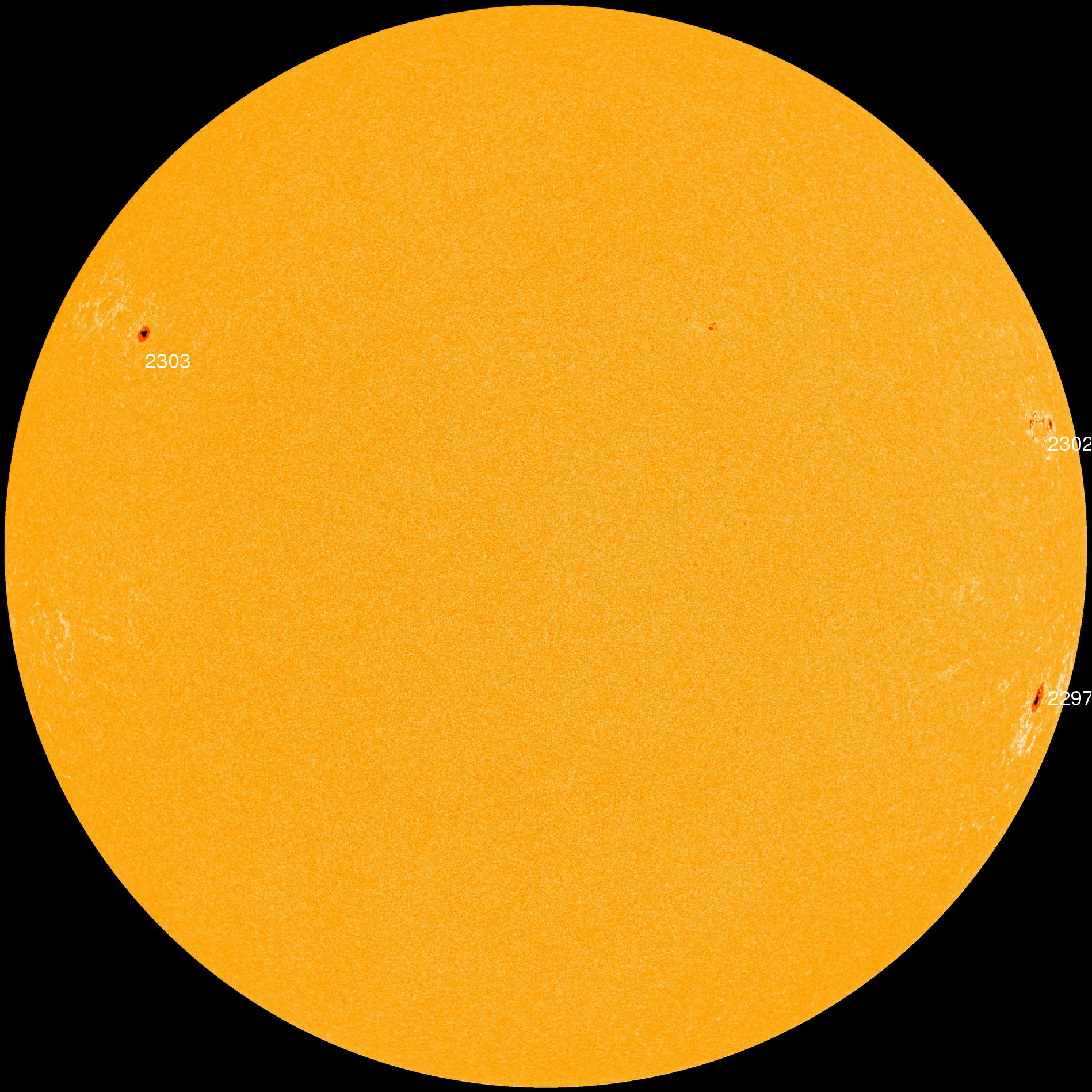
Potentially Hazardous Asteroids (
PHAs) are space rocks larger than approximately 100m that can come closer to Earth than 0.05 AU. None of the known PHAs is on a collision course with our planet, although astronomers are finding
new ones all the time.
On March 19, 2015 there were 1560 potentially hazardous asteroids.
Notes: LD means "Lunar Distance." 1 LD = 384,401 km, the distance between Earth and the Moon. 1 LD also equals 0.00256 AU. MAG is the visual magnitude of the asteroid on the date of closest approach. | | The official U.S. government space weather bureau |
| | The first place to look for information about sundogs, pillars, rainbows and related phenomena. |
| | Researchers call it a "Hubble for the sun." SDO is the most advanced solar observatory ever. |
| | 3D views of the sun from NASA's Solar and Terrestrial Relations Observatory |
| | Realtime and archival images of the Sun from SOHO. |
| | from the NOAA Space Environment Center |
| | the underlying science of space weather |


