Learn to photograph Northern Lights like a pro. Sign up for Peter Rosen's Aurora Photo Courses in Abisko National Park, winner of the TripAdvisor Certificate of Excellence Award 2015. | | |
CO-ROTATING INTERACTION REGION: NOAA forecasters estimate a 40% chance of polar geomagnetic storms on July 10th when a co-rotating interaction region (CIR) is expected to hit Earth's magnetic field. CIRs are transition zones between fast- and slow-moving solar wind streams. Solar wind plasma piles up in these regions, producing density gradients and shock waves that do a good job of sparking auroras. Aurora alerts: text or voice.
SPRITES DANCE OVER EUROPE: Another fine display of red sprites appeared over Europe last night, July 8-9. Lukáš Ronge sends this picture from an observing site near Trutnov, Czech Republic:
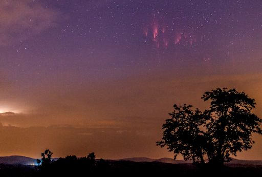
"There has been some very intense lightning activity over central Europe," says Ronge.
Sprites are an exotic form of lightning that shoot up from thunderclouds, not down as ordinary lightning does. The tendrils of red sprites, and their cousins the elves, reach all the way up to the edge of space alongside meteors and noctilucent clouds. They are a true space weather phenomenon.
Indeed, they may be triggered by something from space: cosmic rays. Some researchers think that charged particles from deep space striking the top of Earth's atmosphere produce secondary electrons that, in turn, could provide the spark that triggers sprites.
Although sprites have been seen for at least a century, most scientists did not believe they existed until after 1989 when sprites were photographed by cameras onboard the space shuttle. Now "sprite chasers" regularly photograph the upward bolts from their own homes. Give it a try!
Realtime Sprite Photo Gallery
IT'S PLUTO TIME: After spending almost 10 years hurtling into the void, NASA's New Horizons spacecraft is now only 4 days away from its historic flyby of Pluto. The dwarf planet has never been visited by a spacecraft from Earth, and New Horizons is expected to uncover many surprises. This image captured by New Horizons from a distance of 5 million miles on July 7th is already better than any photo of Pluto ever taken by the Hubble Space Telescope:
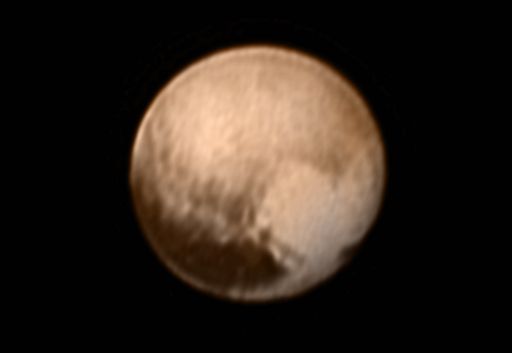
"The next time we see this part of Pluto at closest approach, a portion of this region will be imaged at about 500 times better resolution than we see today," says Jeff Moore of NASA's Ames Research Center. "It will be incredible!"
The light and dark features in this image have been given names such as "the whale" and "the donut." As these temporary labels suggest, the markings are a complete mystery to researchers. The days ahead may reveal their true nature.
Readers of spaceweather.com have been busy processing and improving the raw images NASA is receiving from New Horizons. Browse the photo gallery for examples:
Realtime Pluto Photo Gallery
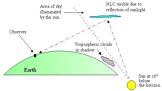
NOCTILUCENT CLOUDS: Summer is the season for noctilucent (night-shining) clouds, and the month of July is often when they are at their best. On July 6th, Jüri Voit photographed these electric-blue ripples over Estonia:
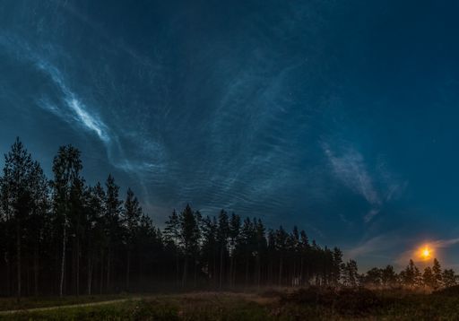
"The combination of moonlight and noctilucent clouds (NLCs) was magical," says Voit. "What a night!"
NLCs are Earth's highest clouds. Seeded by meteoroids, they float at the edge of space more than 80 km above the planet's surface. The clouds are very cold and filled with tiny ice crystals. When sunbeams hit those crystals, they glow electric-blue.
Noctilucent clouds first appeared in the 19th century after the eruption of super-volcano Krakatoa. At the time, people thought NLCs were caused by the eruption, but long after Krakatoa's ash settled, the clouds remained. In recent years, NLCs have intensified and spread with summer sightings as far south as Utah and Colorado. This could be a sign of increasing greenhouse gases in Earth's atmosphere.
Observing tips: Look west 30 to 60 minutes after sunset when the Sun has dipped 6o to 16o below the horizon. If you see luminous blue-white tendrils spreading across the sky, you may have spotted a noctilucent cloud.
Realtime NLC Photo Gallery
Realtime Space Weather Photo Gallery
Realtime Aurora Photo Gallery
Every night, a network of NASA all-sky cameras scans the skies above the United States for meteoritic fireballs. Automated software maintained by NASA's Meteoroid Environment Office calculates their orbits, velocity, penetration depth in Earth's atmosphere and many other characteristics. Daily results are presented here on Spaceweather.com.
On Jul. 9, 2015, the network reported 14 fireballs.
(10 sporadics, 3 July Pegasids, 1 Microscorpiid)
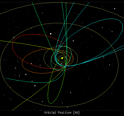
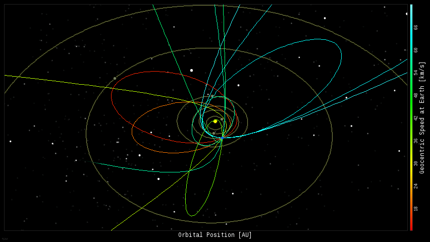
In this diagram of the inner solar system, all of the fireball orbits intersect at a single point--Earth. The orbits are color-coded by velocity, from slow (red) to fast (blue). [Larger image] [movies]
Potentially Hazardous Asteroids (
PHAs) are space rocks larger than approximately 100m that can come closer to Earth than 0.05 AU. None of the known PHAs is on a collision course with our planet, although astronomers are finding
new ones all the time.
On July 9, 2015 there were potentially hazardous asteroids.
Notes: LD means "Lunar Distance." 1 LD = 384,401 km, the distance between Earth and the Moon. 1 LD also equals 0.00256 AU. MAG is the visual magnitude of the asteroid on the date of closest approach. | | The official U.S. government space weather bureau |
| | The first place to look for information about sundogs, pillars, rainbows and related phenomena. |
| | Researchers call it a "Hubble for the sun." SDO is the most advanced solar observatory ever. |
| | 3D views of the sun from NASA's Solar and Terrestrial Relations Observatory |
| | Realtime and archival images of the Sun from SOHO. |
| | from the NOAA Space Environment Center |
| | the underlying science of space weather |
| | Web-based high school science course with free enrollment |


