Learn to photograph Northern Lights like a pro. Sign up for Peter Rosen's Aurora Photo Courses in Abisko National Park. | | |
GLANCING BLOW ON MAY 17: NOAA forecasters estimate a 45% chance of polar geomagnetic storms on May 17th when a CME is expected to deliver a glancing blow to Earth's magnetic field. The storm cloud was hurled in our direction by a magnetic filament, which erupted away from the sun on May 13th. Aurora alerts: text, voice
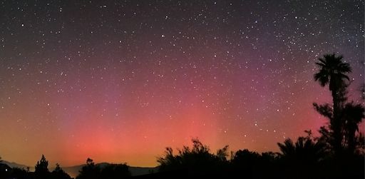
SPACE WEATHER TIME MACHINE: Ten years ago today, the night sky over southern California turned blood red. "During the night and morning of May 14/15, 2005, an extreme geomagnetic storm sparked displays of the northern lights across much of the United States," recalls astrophotographer Dennis Mammana, "and we desert rats got quite a show." He took this picture from the Anza-Borrego Desert:

"On this night, the aurora danced over so wide an area of the northern sky that it required five wide-angle images stitched together to capture it all," says Mammana. "The yellowish glow along the horizon is light pollution from Palm Springs and desert cities to our north."
The display Mammana witnessed occured during the previous solar cycle, Solar Cycle 23, which was fairly strong. In those days, low-latitude auroras were not uncommon. Indeed, in the early 2000s, the staff of spaceweather.com witnessed Northern Lights more than half a dozen times from California's Sierra Nevada mountains.
What a difference 10 years makes. Current Solar Cycle 24 is the weakest solar cycle of the Space Age--and one of the weakest of the past century. There have been no extreme geomagnetic storms, and auroras have not descended to Southern California even once.
The good news? Among researchers, it is well known that extreme geomagnetic storms favor the declining phases of solar cycles--and Solar Cycle 24 is declining! There is still hope for California auroras, after all. Aurora alerts: text, voice
Realtime Aurora Photo Gallery
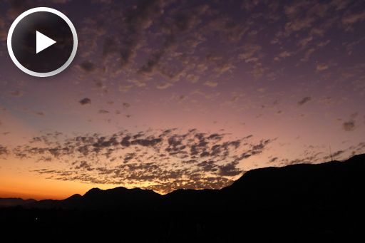
VOLCANIC SUNSETS: Last month, on April 22nd, Chile's erupting Calbuco volcano blew plumes of ash and sulfurous gas more than 50,000 feet high. Since then, the swirling plumes have been spreading around the southern hemisphere. They are quite diffuse now, but still dense enough to color the sunsets of countries where they pass overhead. Just a few evenings ago, Dr. Peter Lowenstein witnessed a volcanic sunset over Murambi East, Mutare, Zimbabwe:

"Zimbabwe continues to have vivid sunsets caused by aerosols from the 22 April eruption of the Calbuco volcano," says Lowenstein. "This movie, which I made on May 10th, is a time lapse sequence of 28 photographs taken at about 20 second intervals."
The purple hue we see in Lowenstein's movie is one of the telltale signs of a volcanic sunset. Fine volcanic aerosols in the stratosphere scatter blue light which, when mixed with ordinary sunset red, produces a violet hue. Purple isn't the only color, though. Volcanic sunsets can also include a bright yellow twilight arch and long diffuse rays and shadows. All of these appeared over Zimbabwe.
Sky watchers in southern Africa, Argentina, Chile, southern parts of Brazil, Australia and New Zealand should remain alert for similar displays as Calbuco's fumes circumnavigate the southern hemisphere. Eventually the aerosols will dissipate. For now, however, the sunsets continue.
Realtime Space Weather Photo Gallery
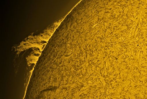
THE 'WOW' PROMINENCE: Around the world, amateur astronomers are monitoring a magnificent structure on the sun. "I looked through my solar scope this morning, and this prominence made me catch myself saying, WOW!" reports John Nassr of Baguio, the Philippines. This is what he saw:

It's called a "hedgerow prominence." Hot glowing plasma inside the structure is held aloft by unstable solar magnetic fields. Space telescopes have taken high resolution images of similar prominences and seen amazing things: (1) tadpole-shaped plumes that float up from the base of the prominence; (2) narrow streams of plasma that descend from the top like waterfalls; and (3) swirls and vortices that resemble van Gogh's Starry Night. Got a solar telescope? Take a look!
Realtime Space Weather Photo Gallery
Realtime Comet Photo Gallery
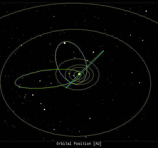
Every night, a network of NASA all-sky cameras scans the skies above the United States for meteoritic fireballs. Automated software maintained by NASA's Meteoroid Environment Office calculates their orbits, velocity, penetration depth in Earth's atmosphere and many other characteristics. Daily results are presented here on Spaceweather.com.
On May. 15, 2015, the network reported 3 fireballs.
(3 sporadics)

In this diagram of the inner solar system, all of the fireball orbits intersect at a single point--Earth. The orbits are color-coded by velocity, from slow (red) to fast (blue). [Larger image] [movies]
Potentially Hazardous Asteroids (
PHAs) are space rocks larger than approximately 100m that can come closer to Earth than 0.05 AU. None of the known PHAs is on a collision course with our planet, although astronomers are finding
new ones all the time.
On May 15, 2015 there were potentially hazardous asteroids.
Notes: LD means "Lunar Distance." 1 LD = 384,401 km, the distance between Earth and the Moon. 1 LD also equals 0.00256 AU. MAG is the visual magnitude of the asteroid on the date of closest approach. | | The official U.S. government space weather bureau |
| | The first place to look for information about sundogs, pillars, rainbows and related phenomena. |
| | Researchers call it a "Hubble for the sun." SDO is the most advanced solar observatory ever. |
| | 3D views of the sun from NASA's Solar and Terrestrial Relations Observatory |
| | Realtime and archival images of the Sun from SOHO. |
| | from the NOAA Space Environment Center |
| | the underlying science of space weather |

