Listen to radar echoes from satellites and meteors, live on listener-supported Space Weather Radio. | | |
THE FIRST MAGNETIC STORM OF SUMMER? NOAA forecasters estimate a 35% chance of minor geomagnetic storms today, June 22nd, when a CME is expected hit hit Earth's magnetic field. High-latitude sky watchers shoud be alert for auroras. Aurora alerts: text, voice
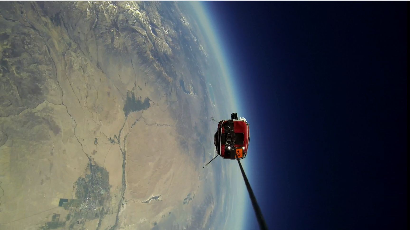
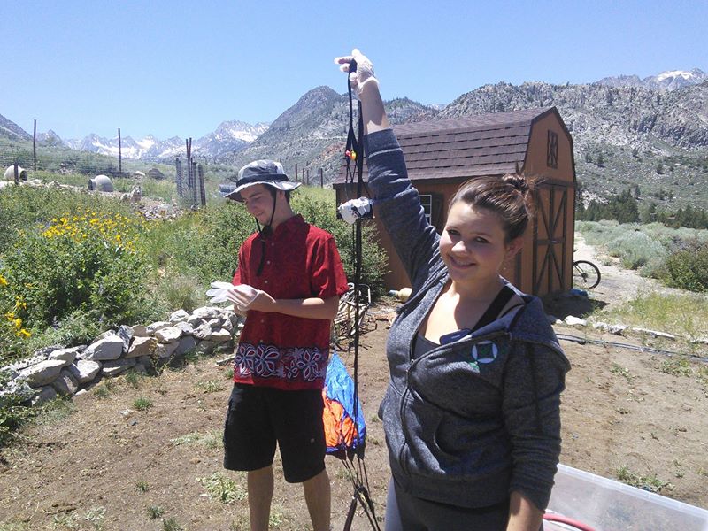
SPACE WEATHER BUOY TAKES SELFIE: Assisted by the students of Earth to Sky Calculus, spaceweather.com has been launching a series of Space Weather Buoys to measure cosmic radiation in the stratosphere. A buoy consists of an insulated payload (a.k.a. K-Mart lunchbox) bristling with sensors and cameras, carried aloft by a suborbital helium balloon. On the latest flight, June 19th, the payload took a selfie. Here it is flying 95,000 feet above Earth's surface:
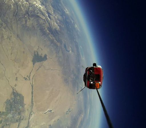
The "SelfieCam" was designed by high school student Carson Reid. It is shown here held up for inspection by launch team member Amelia Koske-Phillips.
The goal of the ongoing experiment is to determine how radiation levels change during solar and geomagnetic storms, and how those changes affect the ozone layer. During each flight, the buoy gathers a complete radiation profile starting at the launch site in California's Eastern Sierras and extending up to 100,000+ feet. Such data are of interest to aviators, entrepreneurs in the emerging space tourism industry, and researchers of the ozone layer. Selfies are a visual bonus.
A complete data set will be released in Oct. 2014 when the student scientists will have collected a full year of radiation measurements, spanning all four seasons and a variety of space weather conditions. Stay tuned.
See also: "Teens launch balloons to the Edge of Space" from the LA Times
SIX-MONTHS IN A BEER CAN: Northern summer has arrived, which means it's time to open a can of beer. A beer-can solargraph, that is. By inserting a roll of photo paper into an empty beer can, and poking a tiny hole in the metal side, the can becomes a pinhole camera capable of recording the sun's motion across the sky. "I left my beer-can solar graph on a fence post for 6 whole months," says David Mead of Dunster, Somerset, UK. Yesterday he opened it and this is what he saw:
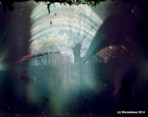
"There was some damage to the can on collecting!" says Mead.
Nevertheless, it made an eerily beautiful image. The lowest arcs were traced by the winter sun of Dec. 2013. The highest arc was made by the sun on the eve of the 2014 summer solstice. Occasional gaps are caused by clouds.
For the record, soda cans work, too. Beautiful results have also been obtained using old-fashioned film canisters. For more information about the variety of ways to make your own device, check out these 6-month Solargraph How-to Guides: #1, #2, #3
Realtime Space Weather Photo Gallery
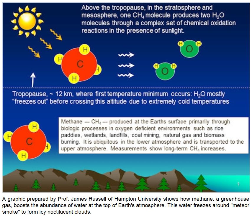
ELECTRIC-BLUE SUMMER CLOUDS: Noctulicent clouds (NLCs) are a phenomenon of summer. Ironically, that is when the top of Earth's atmosphere is cold enough to form ice crystals around meteor smoke--the "stuff" of NLCs. So, you know the summer solstice has arrived when the evening sky starts to look like this:
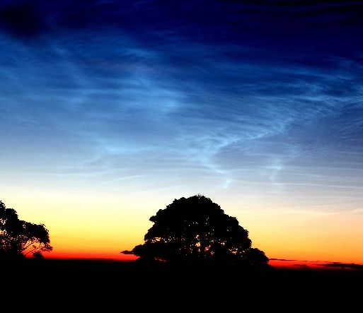
"This fine display of NLCs lasted a number of hours and was visible all across Northern Ireland," says photographer Andy McCrea of Bangor in County Down. "These pictures were taken around 3am on June 20th."
Mark McKenna of Maghera, Northern Ireland, also saw the clouds' signature electric-blue ripples. "This absolutely spectacular noctilucent cloud display was one of the best I have seen in years," he says. "The NLCs were beautiful, glowing vivid white then blue. Of note were the graceful whirls, herringbone, sharp bands and lacunosus holes, the NLCs were even casting shadows onto other NLC forms."
Long ago, NLCs were confined to the Arctic, but in recent years they have been sighted as far south as Colorado and Utah. Some researchers think the increasing visibility is a sign of climate change. Whatever the cause, sky watchers should be alert for NLCs as northern summer unfolds.
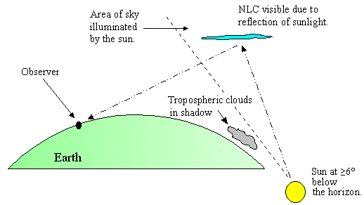
Observing tips: Look west 30 to 60 minutes after sunset when the Sun has dipped 6o to 16o below the horizon. If you see luminous blue-white tendrils spreading across the sky, you may have spotted a noctilucent cloud.
Realtime NLC Photo Gallery
Realtime Aurora Photo Gallery
Realtime Comet Photo Gallery
Every night, a network of NASA all-sky cameras scans the skies above the United States for meteoritic fireballs. Automated software maintained by NASA's Meteoroid Environment Office calculates their orbits, velocity, penetration depth in Earth's atmosphere and many other characteristics. Daily results are presented here on Spaceweather.com.
On Jun. 22, 2014, the network reported 11 fireballs.
( 11 sporadics)
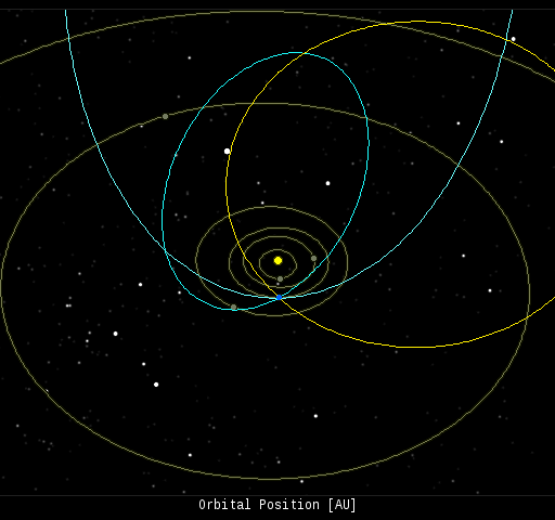
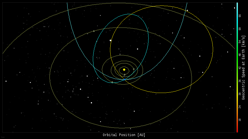
In this diagram of the inner solar system, all of the fireball orbits intersect at a single point--Earth. The orbits are color-coded by velocity, from slow (red) to fast (blue). [Larger image] [movies]
Potentially Hazardous Asteroids (
PHAs) are space rocks larger than approximately 100m that can come closer to Earth than 0.05 AU. None of the known PHAs is on a collision course with our planet, although astronomers are finding
new ones all the time.
On June 22, 2014 there were potentially hazardous asteroids.
Notes: LD means "Lunar Distance." 1 LD = 384,401 km, the distance between Earth and the Moon. 1 LD also equals 0.00256 AU. MAG is the visual magnitude of the asteroid on the date of closest approach. | | The official U.S. government space weather bureau |
| | The first place to look for information about sundogs, pillars, rainbows and related phenomena. |
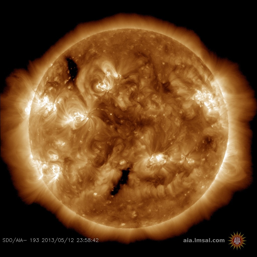
| | Researchers call it a "Hubble for the sun." SDO is the most advanced solar observatory ever. |
| | 3D views of the sun from NASA's Solar and Terrestrial Relations Observatory |
| | Realtime and archival images of the Sun from SOHO. |
| | from the NOAA Space Environment Center |
| | the underlying science of space weather |


