Come to Tromsø and share Marianne's passion for rural photography: Chasethelighttours.co.uk invites you to experience "Heaven on Earth" with an aurora, fjord, fishing, whale watching, photography or sightseeing tour. | | |
QUIET WITH A SLIGHT CHANCE OF STORMS: NOAA forecasters estimate a 30% chance of polar geomagnetic storms on May 29th when a minor solar wind stream is expected to hit Earth's magnetic field. Otherwise, solar and geomagnetic activity is very low. Aurora alerts: text, voice
NOCTILUCENT CLOUDS OVER SCOTLAND: The northern summer season for noctilucent clouds (NLCs) is underway. Earth-orbiting satellites such as AIM and the International Space Station have been photographing the electric-blue clouds for days. Last night, sky watchers on Earth saw them, too. M. J. S. Ferrier sends this picture from Barassie Beach in Ayrshire, Scotland:

The fine-structured blue clouds floating above the dark, ordinary storm clouds are the NLCs. "It was hard to tell the full extent of the display due to a storm system passing through," says Ferrier. "But the noctilucent clouds were definitely there." Jimmy Fraser of Alness, Scotland, also photographed the display. "It was a great start for the NLC season here in northern Scotland," says Fraser.
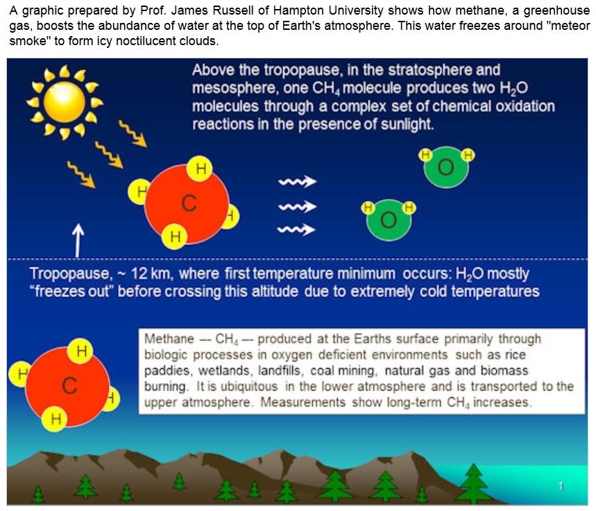
NLCs are Earth's highest clouds. Seeded by meteoroids, they float at the edge of space more than 80 km above the planet's surface. The clouds are very cold and filled with tiny ice crystals. When sunbeams hit those crystals, they glow electric-blue.
Noctilucent clouds first appeared in the 19th century after the eruption of super-volcano Krakatoa. At the time, people thought NLCs were caused by the eruption, but long after Krakatoa's ash settled, the clouds remained. In recent years, NLCs have intensified and spread with sightings as far south as Utah and Colorado. This could be a sign of increasing greenhouse gases in Earth's atmosphere.
Observing tips: Look west 30 to 60 minutes after sunset when the Sun has dipped 6o to 16o below the horizon. If you see luminous blue-white tendrils spreading across the sky, you may have spotted a noctilucent cloud.
Realtime NLC Photo Gallery
RADAR ECHOES FROM THE NOCTILUCENT ZONE: Every summer since the late 1970s, radars probing Earth's upper atmosphere have detected strong echoes from altitudes between 80 km and 90 km. These altitudes comprise the "noctilucent zone," where water vapor crystallizes around meteor smoke to form icy noctilucent clouds (NLCs). The first NLCs of the 2015 northern summer season were spotted by NASA's AIM spacecraft on May 19th. The radar echoes have followed close behind.
Les Dean of the MST Radar Facility in Aberystwyth, Wales, reports: "We detected our first echoes of the summer season on May 26th."
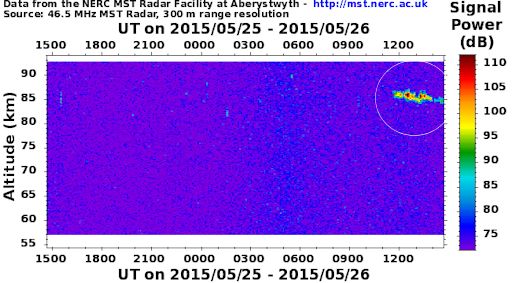
Researchers call them "Polar Mesospheric Summer Echoes" or "PMSEs." They occur over the Arctic during the months of May through August, and over the Antarctic during the months of November through February. These are the same months that NLCs appear.
But do the radar echoes actually come from noctilucent clouds? "The association is controversial," notes Dean. A leading theory holds that the ice particles in noctilucent clouds are electrically charged, and this makes them good reflectors of HF radio waves. However, NLCs are not always visible when the radar echoes are observed and vice versa. So the connection is not clear-cut.
One thing is sure: the northern season for both NLCs and PMSEs has begun. Stay tuned for more echoes from the noctilucent zone.
UPDATE: "What is happening 90 km above Earth's surface?" wonders researcher Rob Stammes at the Polarlightcenter in Lofoten, Norway. For the past two nights, he has detected intense radio reflections using a forward scatter meteor radar. The phenomenon is almost surely linked to the PMSEs and noctilucent clouds reported above.
Realtime Space Weather Photo Gallery
SPRITES OVER OKLAHOMA: On Saturday night, May 23rd, strong thunderstorms raked Texas and Oklahoma, producing torrential rains and deadly floods. Amateur astronomer Thomas Ashcraft could see the lightning bolts all the way from New Mexico--and not all of them were going down. "There was a bright display of sprites shooting up from the tops of the thunderclouds," says Ashcraft. He took this picture using a near-infrared camera at his observatory outside Santa Fe:
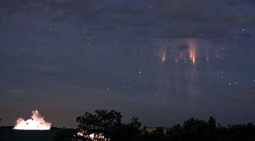
Sprites are an exotic form of lightning that appear very high above Earth's surface, at the edge of space itself.
"Sprites are a true space weather phenomenon," says lightning scientist Oscar van der Velde of the Technical University of Catalonia, Spain. "They develop in mid-air around 80 km altitude, growing in both directions, first down, then up. This happens when a fierce lightning bolt draws lots of charge from a cloud near Earth's surface. Electric fields [shoot] to the top of Earth's atmosphere--and the result is a sprite."
How exotic are they? This close-up view of the Oklahoma sprites says it all:
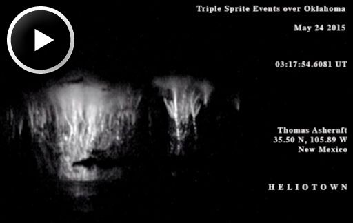
"Turn up the volume," advises Ashcraft. "In the movie you can hear the very low frequency radio crackles from individual lightning strokes."
Although sprites have been seen for at least a century, most scientists did not believe they existed until after 1989 when sprites were photographed by cameras onboard the space shuttle. Now "sprite chasers" routinely photograph sprites from their own homes. Give it a try.
Realtime Sprite Photo Gallery
Realtime Aurora Photo Gallery
Realtime Comet Photo Gallery
Every night, a network of NASA all-sky cameras scans the skies above the United States for meteoritic fireballs. Automated software maintained by NASA's Meteoroid Environment Office calculates their orbits, velocity, penetration depth in Earth's atmosphere and many other characteristics. Daily results are presented here on Spaceweather.com.
On May. 28, 2015, the network reported 24 fireballs.
(24 sporadics)

In this diagram of the inner solar system, all of the fireball orbits intersect at a single point--Earth. The orbits are color-coded by velocity, from slow (red) to fast (blue). [Larger image] [movies]
Potentially Hazardous Asteroids (
PHAs) are space rocks larger than approximately 100m that can come closer to Earth than 0.05 AU. None of the known PHAs is on a collision course with our planet, although astronomers are finding
new ones all the time.
On May 28, 2015 there were potentially hazardous asteroids.
Notes: LD means "Lunar Distance." 1 LD = 384,401 km, the distance between Earth and the Moon. 1 LD also equals 0.00256 AU. MAG is the visual magnitude of the asteroid on the date of closest approach. | | The official U.S. government space weather bureau |
| | The first place to look for information about sundogs, pillars, rainbows and related phenomena. |
| | Researchers call it a "Hubble for the sun." SDO is the most advanced solar observatory ever. |
| | 3D views of the sun from NASA's Solar and Terrestrial Relations Observatory |
| | Realtime and archival images of the Sun from SOHO. |
| | from the NOAA Space Environment Center |
| | the underlying science of space weather |


