Marianne's Heaven On Earth Aurora Chaser Tours Chasethelighttours.co.uk invites you to join them in their quest to find and photograph the Aurora Borealis. Experience the winter wonderland in the Tromsø Area. | | | CO-ROTATING INTERACTION REGION: NOAA forecasters estimate a 40% chance of polar geomagnetic storms on Feb 3rd when a co-rotating interaction region (CIR) is expected to hit Earth's magnetic field. CIRs are transition zones between fast- and slow-moving solar wind streams. Solar wind plasma piles up in these regions, producing density gradients and shock waves that do a good job of sparking auroras. Aurora alerts: text or voice STRATOSPHERIC CLOUD EVENT: Clouds in the stratosphere are very rare. Yet for the past week they have been seen every day. Yesterday, Feb 2nd, Sean Crane of Harrogate UK hopped out of his bath to photograph the display: 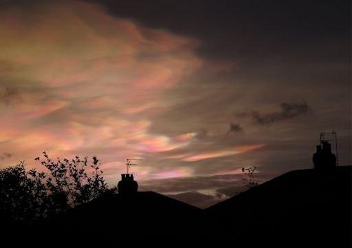
"This is the second day in a row that I have left my early morning bath prematurely to take photos from the garden," says Crane. These fantasticaly-colored clouds are floating more than 80,000 feet above Earth's surface. Normally, the thin air up there is crystal clear. Not this week. Water molecules are crystalizing in the lower stratosphere and the resulting ice crystals are assembling into polar stratospheric clouds (PSCs). Also known as "nacreous" clouds, PSCs form in the lower stratosphere when temperatures drop to a staggeringly-cold -85ºC. High-altitude sunlight shining through tiny ice particles ~10µm wide produce bright iridescent colors by diffraction and interference. Because these clouds require extreme cold, they are most often seen around the Arctic Circle. In recent days, however, they have been spotted as far south as the UK. Indeed, a "stratospheric cloud event" appears to be underway. Monitor the gallery for more sightings: Realtime Stratospheric Cloud Photo Gallery SET YOUR ALARM FOR DAWN: The Great Naked-Eye Planet Show of 2016 is reaching its peak. For the next week, the five brightest planets in the solar system can be seen, all at once, in a great line stretched across the pre-dawn sky. Denis Crute photographed the quintet on Feb. 2nd just before daybreak at Woolgoolga, Australia: 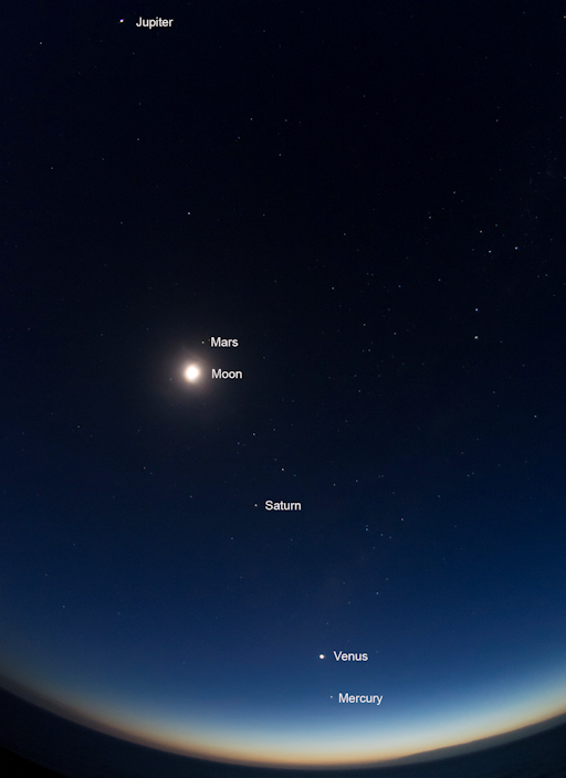
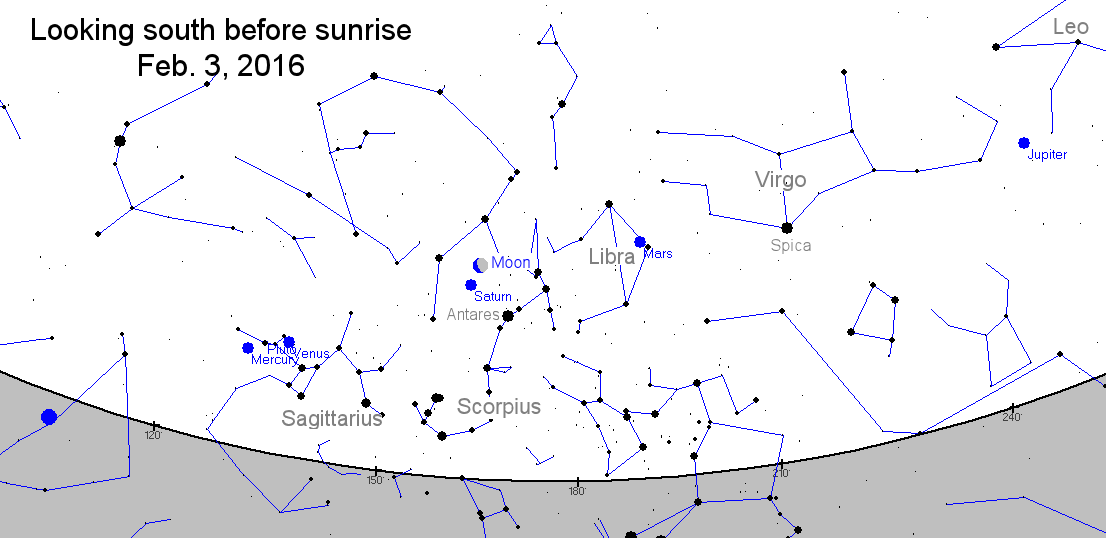
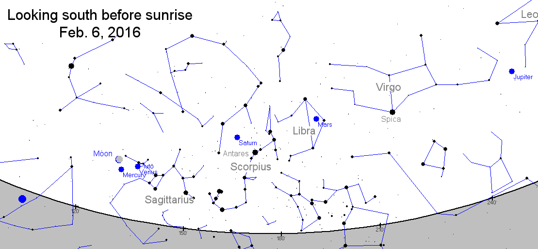
Crute took the picture using a Nikon D5200 digital camera set to ISO 3200 (f3.5) for a 2 sec exposure. Other photographers may wish to note those settings, because there are some excellent photo-ops in the mornings ahead. On Feb. 3rd, the Moon will pass by Saturn in the constellation Scorpius: sky map. On Feb. 6th and 7th, the slender crescent Moon will form a lovely shape-shifting triangle with Venus and Mercury: sky map. Set your alarm for dawn. There's a lot to see. Realtime Aurora Photo Gallery
Realtime Spaceweather Photo Gallery
Realtime Comet Photo Gallery Every night, a network of NASA all-sky cameras scans the skies above the United States for meteoritic fireballs. Automated software maintained by NASA's Meteoroid Environment Office calculates their orbits, velocity, penetration depth in Earth's atmosphere and many other characteristics. Daily results are presented here on Spaceweather.com. On Feb. 3, 2016, the network reported 16 fireballs.
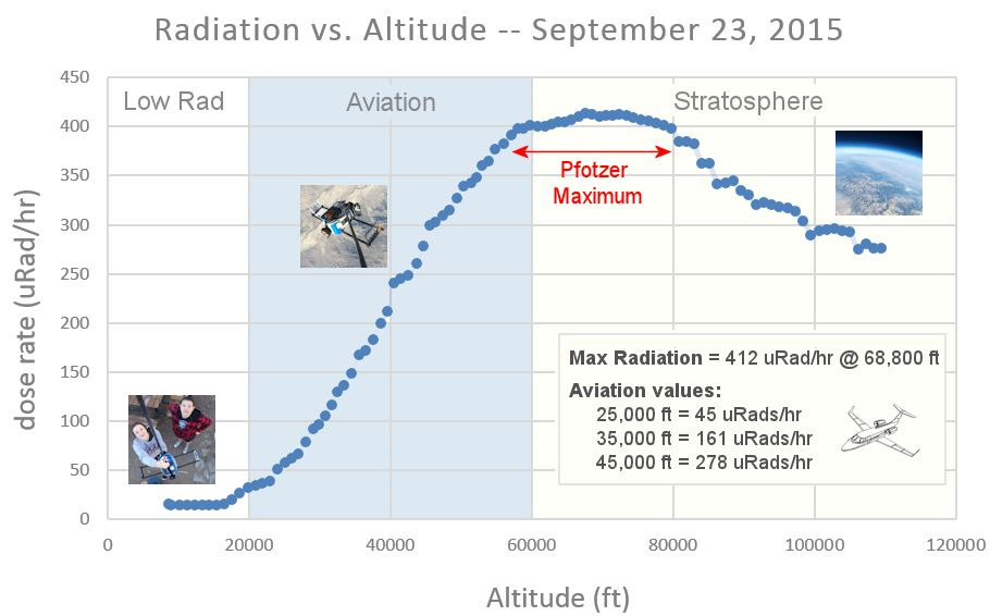
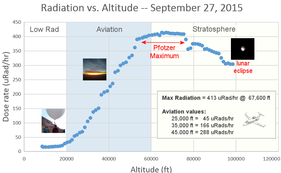
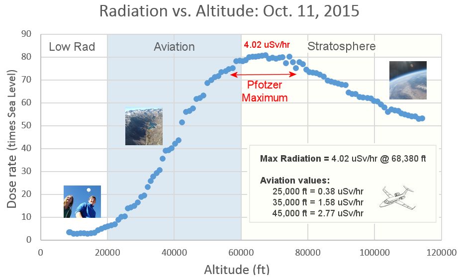
(16 sporadics) 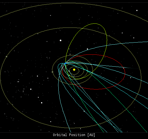 In this diagram of the inner solar system, all of the fireball orbits intersect at a single point--Earth. The orbits are color-coded by velocity, from slow (red) to fast (blue). [Larger image] [movies] Potentially Hazardous Asteroids ( PHAs) are space rocks larger than approximately 100m that can come closer to Earth than 0.05 AU. None of the known PHAs is on a collision course with our planet, although astronomers are finding new ones all the time. On February 3, 2016 there were potentially hazardous asteroids. Notes: LD means "Lunar Distance." 1 LD = 384,401 km, the distance between Earth and the Moon. 1 LD also equals 0.00256 AU. MAG is the visual magnitude of the asteroid on the date of closest approach. | | Cosmic Rays in the Atmosphere | | Situation Report -- Oct. 30, 2015 | Stratospheric Radiation (+37o N) | | Cosmic ray levels are elevated (+6.1% above the Space Age median). The trend is flat. Cosmic ray levels have increased +0% in the past month. | | Sept. 06: 4.14 uSv/hr (414 uRad/hr) | | Sept. 12: 4.09 uSv/hr (409 uRad/hr) | | Sept. 23: 4.12 uSv/hr (412 uRad/hr) | | Sept. 25: 4.16 uSv/hr (416 uRad/hr) | | Sept. 27: 4.13 uSv/hr (413 uRad/hr) | | Oct. 11: 4.02 uSv/hr (402 uRad/hr) | | Oct. 22: 4.11 uSv/hr (411 uRad/hr) | These measurements are based on regular space weather balloon flights: learn more. Approximately once a week, Spaceweather.com and the students of Earth to Sky Calculus fly "space weather balloons" to the stratosphere over California. These balloons are equipped with radiation sensors that detect cosmic rays, a surprisingly "down to Earth" form of space weather. Cosmic rays can seed clouds, trigger lightning, and penetrate commercial airplanes. Our measurements show that someone flying back and forth across the continental USA, just once, can absorb as much ionizing radiation as 2 to 5 dental X-rays. For example, here is the data from a flight on Oct. 22, 2015: 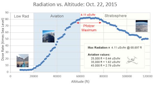
Radiation levels peak at the entrance to the stratosphere in a broad region called the "Pfotzer Maximum." This peak is named after physicist George Pfotzer who discovered it using balloons and Geiger tubes in the 1930s. Radiation levels there are more than 80x sea level. Note that the bottom of the Pfotzer Maximim is near 55,000 ft. This means that some high-flying aircraft are not far from the zone of maximum radiation. Indeed, according to the Oct 22th measurements, a plane flying at 45,000 feet is exposed to 2.79 uSv/hr. At that rate, a passenger would absorb about one dental X-ray's worth of radiation in about 5 hours. The radiation sensors onboard our helium balloons detect X-rays and gamma-rays in the energy range 10 keV to 20 MeV. These energies span the range of medical X-ray machines and airport security scanners. | | The official U.S. government space weather bureau | | | The first place to look for information about sundogs, pillars, rainbows and related phenomena. | | | Researchers call it a "Hubble for the sun." SDO is the most advanced solar observatory ever. | | | 3D views of the sun from NASA's Solar and Terrestrial Relations Observatory | | | Realtime and archival images of the Sun from SOHO. | | | from the NOAA Space Environment Center | | | the underlying science of space weather | | 


