Listen to radar echoes from satellites and meteors, live on listener-supported Space Weather Radio. | | |
THE FIRST INTERPLANETARY PHOTOBOMB: On Friday, July 19th, the Cassini spacecraft will photograph Earth through the rings of Saturn--and NASA wants you to jump into the shot. Get the full story from Science@NASA.
ALIEN CUPCAKES: Yesterday, the students of Earth to Sky Calculus flew a space weather balloon to measure the height of the tropopause. It's part of a project to monitor the effects of solar storms on the upper atmosphere. To support their project, they let a pair of Alien Cupcakes hitch a ride to the edge of space. Check Twitter and Instagram for images from the flight.
AURORAS OVER YELLOWSTONE: A CME swept past Earth on July 13th. The impact was gentle and did not spark a geomagnetic storm. However, south-pointing magnetic fields in the CME's wake had greater effect. The "negative Bz" opened a crack in Earth's magnetosphere, allowing solar wind to pour in and fuel high-latitude auroras. Zack Clothier photographed these over Yellowstone National Park on July 15th:
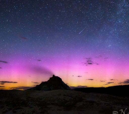
"At about midnight on July 15th, just as the moon was setting, the lights came alive over White Dome Geyser in the Lower Geyser Basin of Yellowstone National Park," says Clothier. "While I was standing there in the darkness a coyote started howling nearby, adding to the already eeriness of the scene. If you look closely you can see a meteor streaking down towards the geyser, to the left of the Milky Way."
More scenes like this are possible on July 18th when a solar wind stream is expected to hit Earth's magnetic field. NOAA forecasters estimate a 50% chance of geomagnetic storms. Aurora alerts: text, voice.
Realtime Aurora Photo Gallery
HOW HIGH ARE NOCTILUCENT CLOUDS? Noctilucent clouds are our planet's highest clouds--but exactly how high are they? The textbook answer is 82-82 km, but textbooks can be wrong. Peter Rosén of Stockholm, Sweden, decided to find out for himself. "On July 4th I photographed some interesting NLCs," he explains. "After uploading them on Spaceweather, I noticed that P-M Hedén had photographed the same formations and at the same time from a location 26 km (16 miles) north of mine. I decided to make precise measurements of the same features in both pictures with respect to the stars and try to determine the exact geographical position and height of these NLCs." Scroll past the images to learn more:
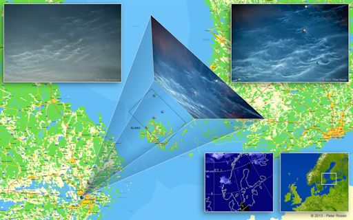
"Some years ago I found a very useful calculator put online by Paul Schlyter to measure the position and altitude of Perseid meteors. By entering the geographical position of both observers and the respective coordinates of an object in the sky, it will compute the position and altitude of the object. In this case, I used it for NLCs."
He picked four features color-coded in the figure above (best seen in the full-sized version) and measured their positions. "The height of these NLCs ranged from 75.1 km (blue dot) to 78.6 km (red dot)," he says. "These results seem to be a little bit lower than the value of 83 km that is often referenced."
Realtime Noctilucent Cloud Photo Gallery
[previous years: 2003, 2004, 2005, 2006, 2007, 2008, 2009, 2011]
Realtime Space Weather Photo Gallery
Realtime Comet Photo Gallery


