SNOW MOON AND JUPITER: There's a full Moon tonight, and according to folklore it has a special name: the Snow Moon, so-called because northern snow often falls most heavily in February. This year the Snow Moon is in conjunction with Jupiter. Look for the duo rising together in the east just after sunset on Feb. 3rd. [sky map]

Last night, Pete Lawrence of Selsey, West Sussex, England, photographed the Moon and Jupiter surrounded by a 22-degree ice halo:

"A fabulous, long-lived lunar halo glowed through the night of Feb 2/3," says Lawrence. "The Moon's position meant that giant planet Jupiter was contained within this stunning ring of light, too. Sometimes tricky to fit inside a camera frame, the wide shot was taken with an 8mm fisheye."
Fitting the pair inside a camera frame will be even easier tonight, when Jupiter and the Moon converge within a tight 5-degree circle. Stay tuned for more photos.
Realtime Space Weather Photo Gallery
SOLAR WIND SPARKS AURORAS: A stream of high-speed solar wind is buffeting Earth's magnetic field, and this is sparking bright auroras around the Arctic Circle. "A geomagnetic storm hit Alaska last night with huge activity seen from horizon to horizon," reports Sacha M. Layos, who sends this picture from Fairbanks:

Normally, full moonlight wipes out auroras, but these auroras were so bright they could be seen despite the glare. Moreover, the moon illuminated the snow-frosted trees, making a photogenic frame for the lights overhead.
More auroras are in the offing. NOAA estimates a 50% chance of continued geomagnetic storming on Feb. 3rd as the solar wind continues to blow. Aurora alerts: text, voice
CLOUDTOP GREEN FLASH: Spaceweather.com reader Mila Zinkova of San Francisco was photographing the sunset on Jan. 29th when a puff of sun detached itself and turned green. It was a rare cloud-top green flash:
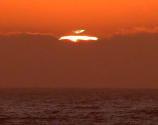
Atmospheric optics expert Les Cowley explains what happened: "San Francisco and the Californian coast is a world top spot for green flashes. Air is cooled by the cold offshore current and topped by warmer air from inland to provide the ideal temperature profile for sunset mirages and flashes."
"Mila's flash might be something extra special - a 'cloud-top' flash. These are seen as the sun's rays graze a distant cloud bank. Marine stratus can be trapped by temperature inversion layers which could generate some of the flashes. But that is not always the case; there is much unexplained about them."