(ALMOST NO) CHANCE OF FLARES: Solar activity is very low and likely to remain so for the next 24 hours. NOAA forecasters estimate a 5% chance of M-flares and no more than a 1% chance of X-flares on Jan. 12th. Solar flare alerts: text or voice.
THE STORM STARTED EARLY: We were expecting a co-rotating interaction region (CIR) to hit Earth's magnetic field on Jan. 12th. It might have arrived a day early. "Here in Inari, Finland, strong auroras appeared on Jan. 11th," reports Rayann Elzein, who photographed a magnificent green outburst over the snowy Lapland:

"This was my last night in Finnish Lapland this January, and I am flying home in a few hours," says Elzein. "What a great way to end a wonderful trip in the Arctic!"
CIRs are transition zones between fast- and slow-moving solar wind streams. Solar wind plasma piles up in these regions, producing density gradients and shock waves that do a good job of sparking auroras. The CIR of Jan. 11th is off to a good start. Aurora alerts: text or voice.
LEAPING SUNDOGS: At this time of year, when northern skies fill with crystals of ice, it is not unusual to see rainbow-colored splashes of light to the left and right of the sun. These are sundogs, formed by the action of ice on sunlight. Yesterday, the daughter of photographer Robert Snache saw a sundog ... and leaped:
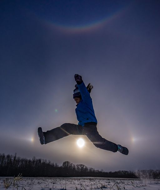
"We had snow squalls in the late afternoon--hence the ice crystals," says Snache, who took the picture from Rama First Nation, Ontario, Canada. "The same crystals formed a smiling rainbow (circumzenithal arc) overhead and a faint 22° halo around the sun. It was a beautiful display of ice halos."
More ice halos are in the offing as northern winter deepens. Browse the gallery for sightings.
Realtime Spaceweather Photo Gallery