CHANCE OF MINOR STORMS: NOAA forecasters say there is a 55% chance of minor G1-class geomagnetic storms on June 16th as Earth continues to move through a region of fast-moving solar wind. High-latitude sky watchers should be alert for auroras, especially in the southern hemisphere where darkening autumn skies favor visibility of faint lights. Aurora alerts: text or voice

RED SPRITES AND GREEN AIRGLOW: Thunderstorm season is underway in the northern hemisphere. That means astrophotographers should point their cameras above the clouds. Thomas Ashcraft did so on June 14th, and he captured two forms of space weather--red sprites and green airglow:

"A large jellyfish sprite appeared over a thunderstorm in the western Oklahoma panhandle last evening," says Ashcraft. "It was about three hundred miles away from my observatory."
"I also caught it in video with very low frequency (VLF) radio emissions, and the parent lightning stroke made a strong pop," he says. Turn up the volume and play the video.
Possibly triggered by cosmic rays, sprites are a form of upper atmospheric that reach up from the tops of thunderstorms toward the edge of space. Although sprites have been seen for at least a century, most scientists did not believe they existed until after 1989 when sprites were photographed by cameras onboard the space shuttle.
The "jellyfish sprite" Ashcraft captured is backlit by a band of green airglow. Airglow surrounds our entire planet, fringing the top of the atmosphere with aurora-like color. Although airglow resembles the aurora borealis, its underlying physics is different. Airglow is caused by an assortment of chemical reactions in the upper atmosphere. Auroras, on the other hand, are ignited by gusts of solar wind.
ICE HALOS REFUSE TO MELT: As summer unfolds across the northern hemisphere, ice and snow are an increasingly distant memory. It's still freezing, however, in the clouds. Ice crystals floating miles above Earth's surface caused this display in Sweden:

"This 22° halo appeared yesterday here in Kiruna," says photographer Mia Stålnacke. "It was beautiful!"
Ice in the clouds can bend sunlight in many interesting ways, forming luminous rings, arcs, and pillars. Collectively these are known as "ice halos." They may be seen around the world during all four seasons--even summer--because it is always freezing miles overhead. Look for them whenever the sun is up and the blue sky is criss-crossed by icy cirrus clouds.
More examples may be found in the realtime photo gallery:
Realtime Space Weather Photo Gallery
NOCTILUCENT OUTBURST: On June 13th, observers in more than half a dozen European countries witnessed a brilliant apparition of noctilucent clouds. Ruslan Merzlyakov sends this picture from Nykøbing Mors, Denmark:

"Their brightness peaked from 00:50 to 1:20 and then, suddenly, they were almost gone," says Merzlyakov, who recorded a video of the display.
Noctilucent clouds are a space weather phenomenon. They are seeded by meteoroids and hover 83 km above Earth's surface at the threshold of space. Summer is the season for NLCs because, ironically, that is when the upper atmosphere is cold enough for ice crystals to form around meteoroids in the mesosphere.
Noctilucent clouds were first reported by Europeans in the late 1800s. In those days, you had to travel to latitudes well above 50o to see them. Now, however, NLCs are spreading. In recent years they have been sighted as far south as Colorado and Utah in the United States. Many researchers suspect this is a side-effect of climate change.
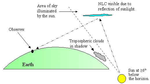
Observing tips: Look west 30 to 60 minutes after sunset when the Sun has dipped 6o to 16o below the horizon (diagram). If you see blue-white tendrils spreading across the sky, you may have spotted a noctilucent cloud.
Realtime Noctilucent Cloud Photo Gallery