SUBSIDING CHANCE OF STORMS: NOAA forecasters have downgraded the odds of a geomagnetic storm on June 17th to only 20% as Earth exits a stream of fast solar wind. Auroras are unlikely tonight. Aurora alerts: text or voice
POLAR STRATOSPHERIC CLOUDS: Bright colors have appeared in the skies over Antarctica--but it's not the aurora australis. Instead, pastel stratospheric clouds are floating over the frozen continent. B. Sudarsan Patro photographed the apparition on June 17th from the Bharati Indian Base Station:
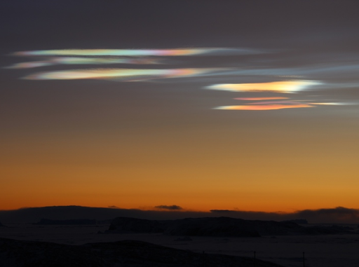
"The clouds were absolutely stunning," says Patro. "It was really surprising and a new experience for all of us."
Atmospheric optics expert Les Cowley says "Bharati Station at 70 degrees south is just the place to get these wonderful filmy Polar Stratospheric Clouds (PSCs). Floating 9 to 16 miles high, they need stunningly-cold temperatures below -85 Celsius to form."
"More familiar tropospheric clouds can also shine with iridescent colours," he says, "but never as vividly or memorably as PSCs. This page helps distinguish the two."
Realtime Space Weather Photo Gallery
FARSIDE SOLAR ACTIVITY: The Earth-side of the sun is quiet, with only two sunspots producing very low-level flares. The farside of the sun, however, is more active. On June 16th, the Solar and Heliospheric Observatory detected this CME billowing over the sun's northeastern limb:

The source of the explosion is on the other side of the sun. It might be an active sunspot hidden from view by the body of the sun. If so, more CMEs are possible in the days ahead as the sunspot continues to flare. None of the CMEs, however, would be geoeffective until the active region turns toward Earth. For now, Earth-directed solar activity remains very low. Solar flare alerts: text or voice
Realtime Space Weather Photo Gallery
RED SPRITES AND GREEN AIRGLOW: Thunderstorm season is underway in the northern hemisphere. That means astrophotographers should point their cameras above the clouds. Thomas Ashcraft did so on June 14th, and he captured two forms of space weather--red sprites and green airglow:

"A large jellyfish sprite appeared over a thunderstorm in the western Oklahoma panhandle last evening," says Ashcraft. "It was about three hundred miles away from my observatory."
"I also caught it in video with very low frequency (VLF) radio emissions, and the parent lightning stroke made a strong pop," he says. Turn up the volume and play the video.
Possibly triggered by cosmic rays, sprites are a form of upper atmospheric that reach up from the tops of thunderstorms toward the edge of space. Although sprites have been seen for at least a century, most scientists did not believe they existed until after 1989 when sprites were photographed by cameras onboard the space shuttle.
The "jellyfish sprite" Ashcraft captured is backlit by a band of green airglow. Airglow surrounds our entire planet, fringing the top of the atmosphere with aurora-like color. Although airglow resembles the aurora borealis, its underlying physics is different. Airglow is caused by an assortment of chemical reactions in the upper atmosphere. Auroras, on the other hand, are ignited by gusts of solar wind.
Realtime Noctilucent Cloud Photo Gallery