POLAR MAGNETIC STORMS: Minor G1-class geomagnetic storms are underway on Oct. 4th as Earth slowly exits a high-speed stream of solar wind. Polar sky watchers should remain alert for auroras: realtime photo gallery.

RED AIRGLOW OVER EASTER ISLAND: Not every colorful light in the night sky is an aurora. Especially not in the South Pacific. Yuri Beletsky was on a beach in Easter Island, Chile, two nights ago when the starry canopy turned red:

"There was no fire," says Beletsky. "This is an amazing display of airglow."
Airglow is aurora-like phenomenon caused by chemical reactions in the upper atmosphere. Human eyes seldom notice the faint glow, because it is usually very faint, but it can be photographed on almost any clear dark night, anywhere in the world.
Beletsky is a veteran photographer of airglow, having captured it dozens of times from sites in Chile and the South Pacific. "The intensity of airglow varies, and sometimes it can be more prominent, as it was on Oct. 2nd," he says.
The curious thing about Beletsky's photo is not the intensity of the airglow, but rather its color--red. Airglow is usually green, the color of light from oxygen atoms some 90 km to 100 km above Earth's surface. Where does the red come from? Instead of oxygen, OH can produce the ruddy hue. These neutral molecules (not to be confused with the OH- ion found in aqueous solutions) exist in a thin layer 85 km high where gravity waves often impress the red glow with a dramatic rippling structure.
Realtime Airglow Photo Gallery
NEXT STOP, SATURN: On Oct. 3rd, sky watchers around the world saw the crescent Moon pass by Venus. Enrico Finotto photographed the encounter from Treviso, Italy:

"It was a beautiful evening sunset conjunction of Venus and the Moon," says Finotto. "I photographed them using my Canon 760D camera set at ISO 200 for a 1.3 sec exposure."
Next stop: Saturn. The Moon is moving past Venus en route to the ringed planet for a similar pairing on Oct. 5th. Make note of Finotto's photo settings. They might come in handy on Wednesday evening: sky map.

Realtime Space Weather Photo Gallery
SPRITES ABOVE HURRICANE MATTHEW: On Oct. 1st, Earth weather met space weather above Hurricane Matthew. As the giant storm system was approaching the Greater Antilles, Frankie Lucena of Puerto Rico photographed red sprites shooting up from the thunderclouds:

Sprites are a strange and beautiful form of lightning that shoot up from the tops of electrical storms. They reach all the way up to the edge of space alongside meteors, auroras, and noctilucent clouds. Some researchers believe cosmic rays help trigger sprites, making them a true space weather phenomenon.
Seeing sprites above a hurricane is rare. Many hurricanes don't even have regular lightning because the storms lack a key ingredient for electrical activity: vertical winds. (For more information read the Science@NASA article "Electric Hurricanes.") But Matthew is not a typical hurricane. It's one of the most powerful in recent years, briefly reaching Category 5 at about the time Lucena photographed the sprites. Perhaps extra-strong winds in the vicinity of the storm set the stage for upward-reaching bolts.
Sprite photographers across the Caribbean and the southeastern USA should be alert for more as the storm system approaches the mainland: observing tips.
 |
| Cosmic Rays in the Atmosphere |
|
Updated: Sept. 29 2016 // Next Flight: Oct. 1, 2016
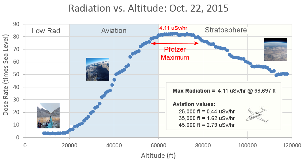
Sept. 20, 2016: Readers, thank you for your patience while we continue to develop this new section of Spaceweather.com. We've been working to streamline our data reduction, allowing us to post results from balloon flights much more rapidly, and we have developed a new data product, shown here:

This plot displays radiation measurements not only in the stratosphere, but also at aviation altitudes. Dose rates are expessed as multiples of sea level. For instance, we see that boarding a plane that flies at 25,000 feet exposes passengers to dose rates ~10x higher than sea level. At 40,000 feet, the multiplier is closer to 50x. These measurements are made by our usual cosmic ray payload as it passes through aviation altitudes en route to the stratosphere over California.
What is this all about? Approximately once a week, Spaceweather.com and the students of Earth to Sky Calculus fly space weather balloons to the stratosphere over California. These balloons are equipped with radiation sensors that detect cosmic rays, a surprisingly "down to Earth" form of space weather. Cosmic rays can seed clouds, trigger lightning, and penetrate commercial airplanes. Furthermore, there are studies ( #1, #2, #3, #4) linking cosmic rays with cardiac arrhythmias and sudden cardiac death in the general population. Our latest measurements show that cosmic rays are intensifying, with an increase of more than 12% since 2015:

Why are cosmic rays intensifying? The main reason is the sun. Solar storm clouds such as coronal mass ejections (CMEs) sweep aside cosmic rays when they pass by Earth. During Solar Maximum, CMEs are abundant and cosmic rays are held at bay. Now, however, the solar cycle is swinging toward Solar Minimum, allowing cosmic rays to return. Another reason could be the weakening of Earth's magnetic field, which helps protect us from deep-space radiation.
The radiation sensors onboard our helium balloons detect X-rays and gamma-rays in the energy range 10 keV to 20 MeV. These energies span the range of medical X-ray machines and airport security scanners.
The data points in the graph above correspond to the peak of the Reneger-Pfotzer maximum, which lies about 67,000 feet above central California. When cosmic rays crash into Earth's atmosphere, they produce a spray of secondary particles that is most intense at the entrance to the stratosphere. Physicists Eric Reneger and Georg Pfotzer discovered the maximum using balloons in the 1930s and it is what we are measuring today.