AURORAS IN CANADA AND THE USA: For the 3rd day in a row, Earth is inside a stream of high-speed solar wind, which is sparking intermitent G1-class geomagnetic storms around the Arctic Circle. Last night in Churchill, Manotiba, "the entire sky turned green," reports Alan Dyer, who says the storm was actually subsiding when he took this picture:


"There was rapid motion and rippling effects, with some nitrogen pinks along the bottom edge of the curtains," he says.
The display was so intense, it spilled over into the USA. Just south of the Canadian border, Kevin Palmer photographed the geomagnetic glow from Saint Xavier, Montana:

"The aurora showed itself low on the northern horizon," says Palmer. "The Bighorn River made a nice reflection."
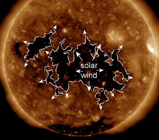
The stream of solar wind is flowing from a wide hole in the sun's atmosphere--so wide that we may feel its emissions for another 24 to 48 hours. High-latitude sky watchers should remain alert for auroras this weekend. Aurora Alerts: SMS text, email.
SPACE WEATHER ALERTS: Spaceweather.com is proud to announce our new and improved space weather alert system. Sign up now and you'll never miss another solar storm in 2019. Subscribers receive instant text messages when there are solar flares, geomagnetic storms, and CMEs about to strike Earth. And if you sign up for the PRO PLAN, you'll receive a type of notification available no where else--"Magnetic Crack" alerts. Keep reading after the graphic to learn more:

PRO PLAN subscribers get a text message whenever a crack is opening in Earth's magnetosphere. Magnetic cracks are caused by south-pointing magnetic fields ("BsubZ") in the solar wind, which partially cancel Earth's magnetic defenses. Solar wind pours in through these cracks to fuel bright auroras and geomagnetic storms. Veteran aurora chasers know that watching "BsubZ" is the best way to anticipate geomagnetic activity. Now your cell phone can do this job for you, alerting you when cracks are forming in the invisible magnetic field overhead.
Get started for as little as $4.95 per month.
Far Out Gifts: Earth to Sky Store
All sales support hands-on STEM education
A SUNDOG FALLS THROUGH A HOLE IN THE CLOUDS: Jan. 28th was a cloudy day in Lynden, Washington. Suddenly, a hole formed in the cloud deck--and a sundog fell through. Ben Ellis was out for a run and photographed the phenomenon with his iPhone:

What happened? Ellis witnessed a "fallstreak hole." These can form in high altitude clouds when the temperature drops below 0o C-- but water droplets in the cloud do not freeze. They remain in a supercooled liquid state, delicate and unstable. Suddenly, a disturbance occurs; perhaps a plane flies by. The sub-zero water droplets begin to crystallize in a wave expanding outward from the point of the disturbance. Ice crystals billow from the resulting "hole."
As ice crystals fell from this fallstreak hole, they caught the rays of the nearby sun, forming a rainbow-colored sundog.
Realtime Space Weather Photo Gallery