MERCURY PROBE TO SLINGSHOT PAST EARTH: Tonight, Europe's BepiColombo spacecraft will fly past Earth in a slingshot maneuver designed to send it toward Mercury. At closest approach (April 10 @ 0425 UT) it will be just 12,677 km over the South Atlantic Ocean. Shining like an 8th magnitude star, BepiColumbo will not be visible to the naked eye, but it could be an easy target for telescopes especially in South America and southern Africa. Flyby predictions: Heavens Above, ESA.
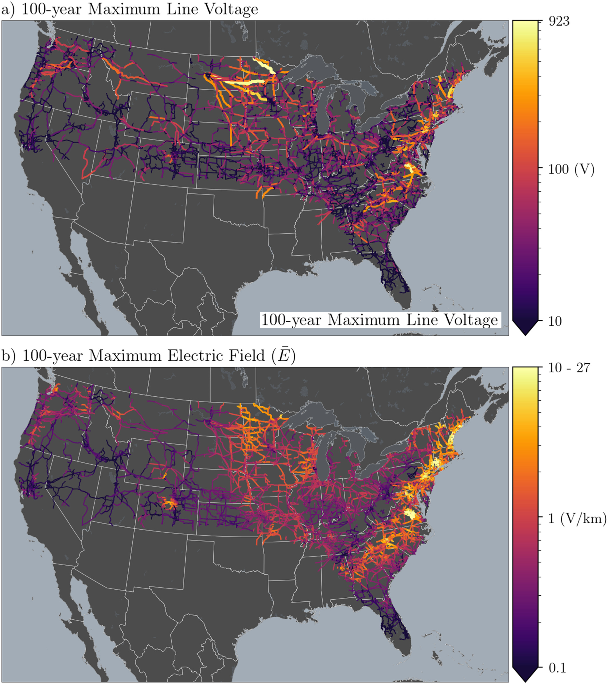
WHERE THE POWER GOES OUT: A solar superstorm can make your lights go out. New maps released by the USGS show where the power is most likely to fail: The Denver metropolitan area, the Pacific northwest, the Atlantic seaboard, and a cluster of Midwestern states near the US-Canadian Border. Bright yellow and orange trace the trouble spots across the contiguous USA:
Power companies have long been wary of the sun. Solar storms can cause strong electric currents to flow through commercial power lines--so strong that the lines can't handle it. Fuses blow, transformers melt, and circuit breakers trip. The most famous geomagnetic power outage happened during a space storm in March 1989 when six million people in Quebec lost power for 9 hours.
Whether or not *your* power goes out during a solar storm depends on two things: (1) The configuration of power lines in your area and (2) the electrical properties of the ground beneath your feet. In areas of more electrically resistive rock, currents struggle to flow through the ground. Instead, they leap up into overhead power lines – a scenario that played out in Quebec in 1989.
The new maps are possible thanks to Earthscope--a National Science Foundation magnetotelluric survey of the upper 2/3rds of the contiguous USA. Earthscope mapped the electrical properties of deep rock and soil on a continent-spanning grid with points about 70 km apart. USGS researchers led by Greg Lucas and Jeffrey Love combined this information with the layout of modern power lines to estimate peak voltages during a century-class storm.

Sprawling power lines act like "solar storm antennas," picking up currents and spreading the problem over a wide area.
They found a huge variation in hazard across the USA. "The largest estimated once-per-century geoelectric field is 27.2 V/km at a site located in Maine, while the lowest estimated once-per-century geoelectric field is 0.02 V/km at a site located in Idaho. That is more than 3 orders of magnitude difference," they wrote in their research paper "A 100‐year Geoelectric Hazard Analysis for the U.S. High‐Voltage Power Grid." Notably, some of the most vulnerable regions are near big cities: Denver, Boston, New York, Philadelphia, Baltimore, and Washington, DC.
To complete the hazard map, the researchers are waiting for a new magnetotelluric survey to cover the rest of the USA. It can't come soon enough. The last "century-class" geomagnetic storm hit in May 1921 ... 99 years ago.
Realtime Space Weather Photo Gallery
Free: Spaceweather.com Newsletter
A MOTHER'S DAY GIFT FROM THE STRATOSPHERE: Tell Mom how much you love her -- to the Moon and Back! On March 5th, the students of Earth to Sky Calculus launched an array of cosmic ray sensors to the edge of space onboard a helium balloon. This Mother's Day pendant went along for the ride:

The silvery crescent declares "I love you to the Moon and Back" and surrounds a 14K gold plated heart labeled "Mom."
You can have it for $99.95. The students are selling these pendants to support their cosmic ray ballooning program. Each one comes with a greeting card showing the item in flight and telling the story of its journey to the edge of space. Sales support the Earth to Sky Calculus cosmic ray ballooning program and hands-on STEM research.
Far Out Gifts: Earth to Sky Store
All sales support hands-on STEM education
Realtime Aurora Photo Gallery
Free: Spaceweather.com Newsletter